
Mount Edith Cavell
| Mount Edith Cavell | ||
|---|---|---|
 North face of Mount Edith Cavell |
||
| height | 3363 m | |
| location | Alberta ( Canada ) | |
| Mountains | Canadian Rockies | |
| Dominance | 47.17 km → Mount Clemenceau | |
| Notch height | 2023 m ↓ Fortress Pass (1340 m) | |
| Coordinates | 52 ° 40 '2 " N , 118 ° 3' 25" W | |
| Topo map | Amethyst Lakes 83 D / 9 | |
|
||
| First ascent | 1915 by AJ Gilmour and EWD Holway | |
| Normal way | West Ridge ( UIAA II ) | |

The Mount Edith Cavell is a mountain in the Canadian Rocky Mountains in the Canadian province of Alberta .
It is located in Jasper National Park, southwest of the city of Jasper , west of the Athabasca River . The mountain was named in 1916 after the nurse Edith Cavell , who was executed by the Germans in Belgium during the First World War . Previously, his name was Montagne de la Grande Traversée ("Mountain of the Great Crossing") because it is on the way to the Athabasca Pass.
The first ascent of the 3363 m high mountain was made in 1915 by AJ Gilmour and EWD Holway.
A 17 km long winding road leads from Jasper to Mount Edith Glacier . The west ridge of the mountain continues in a semicircular arc to the north and east. The Angel Glacier feeds in this basin .
photos

Glacier lake on Mount Edith Cavell, September 2, 2009

The Angel Glacier on the north side.
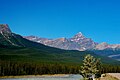
The east side of the Icefields Parkway from the Athabasca River valley.


Web links
- Mount Edith Cavell, Alberta on Peakbagger.com (English)
- Mount Edith Cavell on bivouac.com (English)
- Homepage of Jasper National Park