Mount Isa City
| City of Mount Isa | |
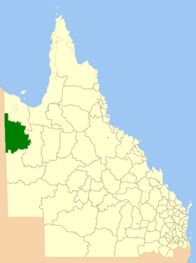
 Location of Mount Isa City in Queensland |
|
| structure | |
| State : |
|
| State : |
|
| Administrative headquarters: | Mount Isa |
| Dates and numbers | |
| Area : | 43,713.0 km² |
| Residents : | 18,671 (2016) |
| Population density : | 0.4 inhabitants per km² |
| Wards : | 12 |
Coordinates: 20 ° 43 ′ S , 139 ° 29 ′ E The City of Mount Isa is a local government area (LGA) in the Australian state of Queensland . The area is 43,713 km² and has about 18,700 inhabitants.
geography
Mount Isa is in the northwest of the state and borders the Northern Territory . It is about 1,560 km from the capital, Brisbane .
The LGA's administrative headquarters are located in downtown Mount Isa . The 24 neighborhoods include Barkly, Breakaway, Camooweal , Fisher, Gunpowder, Happy Valley, Healy, Kalkadoon, Lanskey, Menzies, Mica Creek, Miles End, Mornington, Mount Isa, Mount Isa City, Parkside, Pioneer, Ryan, Soldiers Hill, Spreadborough , Sunset, The Gap, Townview and Winston.
history
In 1963 the city of Mount Isa was merged with the Barkly Tableland Shire and part of the Cloncurry Shire to form Mount Isa Shire. Five years later the LGA was given city status.
administration
The Mount Isa City Council has seven members. The Mayor and six other Councilors are elected by all residents of the City. The LGA is not divided into electoral districts.
Web links
- Official site of the Mount Isa City Council (English)
- Queensland Places: Mount Isa Shire and City (English)
Individual evidence
- ↑ a b Australian Bureau of Statistics : Mount Isa (C) ( English ) In: 2016 Census QuickStats . June 27, 2017. Retrieved May 14, 2020.