Mount Isa
| Mount Isa | |||||||
|---|---|---|---|---|---|---|---|

|
|||||||
|
|||||||
|
|||||||
|
|||||||
|
|||||||
|
|||||||
|
|
|||||||
The Australian city of Mount Isa is the largest and most important city in the North West region of the state of Queensland and the seat of the local administrative area of the same name (LGA) Mount Isa City .
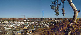
The name Mount Isa refers to a nearby hill where significant ore deposits are located. Their exploitation, which began in 1923 by European immigrants, created the basis for urban development. The continued importance of mining for the economic life of the city reflects the chimney of the lead melt resist, which towers over 265 meters above sea level the landscape.
history
Before the European settlement, the area was inhabited by the Kalkadoon , a tribe of the Aborigines , who used the barren soil as grazing land .
In 1844/1845 the Australian-German researcher Ludwig Leichhardt passed by not too far from today's Mount Isa when he was crossing northeast Australia. An initially successful guerrilla war of the Kalkadoon developed against the European conquest, which was soon to begin . But after their siege of a fort, in 1884 a bloody battle broke out in the area of today's Mount Isa, in which the Kalkadoon were finally defeated.
1923 saw John Campbell Miles in the area of present-day Mount Isa, at the western edge of the Cloncurry -field, a erzreiches silver - lead - seam and the place named after his sister Isabella Mount Isa . Four years later, in 1927, the then Mount Isa Mines company began building a town on the banks of the Leichhardt River . In 1931 the mining of silver and lead began. Eleven years later, in 1942, significant deposits of copper ore were also found, and 195? further silver-lead and zinc deposits. These ore discoveries fueled the growth of the settlement, which was elevated to a city in 1968.
In 1960, Queenslands founded the School of the Air in Mount Isa , which is responsible for the distance learning of preschool and elementary school children in the Queensland outback . In 1964 the Royal Flying Doctor Service , which is responsible for the medical care of these remote areas, was relocated to Mount Isa.
In 1964/1965 there were fierce and violent labor disputes in Mount Isa, which led to the city being placed under martial law . In connection with the mining activity - similar to German opencast mining areas - individual districts were also relocated.
geography
The northwest region (also called Gulf Country ) lies along the coast of the Gulf of Carpentaria and is predominantly arid or savannah. Of the 36,000 inhabitants (28% Aborigines), 25,000 live in the vicinity of Mount Isa. The nearest of the 6 other cities in the region is Cloncurry 100 km to the east.
Mount Isa lies in the rather flat but rocky area of the Barkly Tableland on the northeastern slope of the Selwyn Range . The city is surrounded by dry savannah and semi-desert and is traversed by the Leichhardt River, which, however, usually does not have water all year round. It was dammed north of the city (13-20 km downstream) to Lake Moondarra , which provides the city with the necessary drinking and industrial water all year round and is also used for water sports activities.
climate
The climate in Mount Isa, which is more moderate than in other areas of the region due to the surrounding mountain ranges, can be characterized as a tropical continental climate - the Gulf of Carpentaria is 340 km north and the Coral Sea 740 km in an east-northeast direction - with three Seasons. The rainy season with its high temperatures, in which more than three quarters of the annual precipitation falls, is in the southern summer from January to April. The dry season falls into a warm period from May to August and a hot period from September to December. In the summer months, the maximum daily temperature can significantly exceed 40 ° C; the highest measured temperature value of 45.9 ° C was recorded on January 29, 1995. In the southern winter the temperature can drop deeply; the lowest temperature measured in Mount Isa was recorded on July 7, 1984 at −2.96 ° C. Freezing temperatures can occur in June, July and August. Temperatures usually fluctuate around 10–15 ° C all year round during the day. The precipitation mostly comes from thunderstorms and, in spring and summer, from moving trough systems, but occasionally long-lasting heavy rain is brought about by former tropical cyclones .
In July, i.e. in southern winter, the temperature fluctuates on average between 10.0 ° C and 24.7 ° C daily, in January, i.e. in southern summer, between 24.3 ° C and 37.6 ° C. Given these high temperatures, the average annual rainfall of around 357 mm is quite small. The wettest year since weather records began was 1974 with 864 mm, while the driest year was 1970, when only 171 mm of rain fell.
| Mount Isa | ||||||||||||||||||||||||||||||||||||||||||||||||
|---|---|---|---|---|---|---|---|---|---|---|---|---|---|---|---|---|---|---|---|---|---|---|---|---|---|---|---|---|---|---|---|---|---|---|---|---|---|---|---|---|---|---|---|---|---|---|---|---|
| Climate diagram | ||||||||||||||||||||||||||||||||||||||||||||||||
| ||||||||||||||||||||||||||||||||||||||||||||||||
|
Average Monthly Temperatures and Rainfall for Mount Isa
Source: Australian Bureau of Meteorology : Mount Isa Aero Station. Observation period: 1966–2013 (hours of sunshine 1975–2013). Retrieved January 11, 2014.
|
|||||||||||||||||||||||||||||||||||||||||||||||||||||||||||||||||||||||||||||||||||||||||||||||||||||||||||||||||||||||||||||||||||||||
economy
Mount Isa emerged as a mining town, and mining continues to form the basis of the town's economic life to this day . Mt. Isa Mines (MIM, 100% owned by Xstrata ) operates two separate processing plants for copper and zinc-lead ores in Mt. Isa. Two underground copper mines (Enterprise and X41) extract up to 6.5 million tons of ore per year, from which 300,000 tons of anode copper and 130,000 tons of copper in concentrate are extracted. Copper mining is the deepest in Australia at up to 1,900 m. Zinc-lead ores are extracted from two opencast mines (Blackstar and Handlebar) and one underground mine (George Fisher). The processing has an annual capacity of 6.5 million tons of ore and produces 300,000 tons of zinc in concentrate and 130,000 tons of lead ingot in the connected lead smelter. Silver and gold are extracted as by-products. Mining products are transported for shipping to the port city of Townsville , about 900 km away .
In addition, the area around the city, like large parts of the Queensland outback, is used for extensive cattle farming.
traffic
Mount Isa is on the Barkly Highway . This west-east trunk road connects Townsville on the east coast with Tennant Creek in the Northern Territory , and Mount Isa indirectly also with Queensland's capital Brisbane , which is 1,847 kilometers by road, and the cities of the Northern Territory .
Mount Isa is also connected to Townsville by a railway line, on which a "The Inlander" passenger train commutes between the two cities twice a week.
There are also long-distance bus routes and an airport.
Leisure and tourism
Mount Isa is home to the Outback at Isa Museum , which houses the Riversleigh Fossil Center , which reports on the important fossil finds of large prehistoric mammals near Riversleigh in the Lawn Hill National Park to the northwest of the city .
You can also visit the visitor center of the Royal Flying Doctor Service and the School of the Air . The latter is responsible for the pre-school and primary school distance learning of around 280 North Queensland students.
The city also enjoys a certain fame of their carnival parades and their rodeo events Select sake.
North of the city there are two reservoirs , Lake Moondarra and Lake Julius , which are ideal for water sports activities.
In the more distant vicinity of the city there are also two national parks, Lawn Hill National Park, famous for its fossil finds and adorned with picturesque gorges, and Camooweal Caves National Park, which is unique in Queensland and is home to Cambrian caves .
Personalities
- Simmone Jade Mackinnon (* 1973), Australian actress
- Deborah Mailman (born 1972), Australian actress
- Greg Norman (* 1955), Australian professional golfer
- Patrick Rafter (* 1972), Australian professional tennis player
- John White (* 1973), professional squash player
literature
- Appleton, Richard & Barbara: "The Cambridge Dictionary of Australian Places" Cambridge University Press, Cambridge, 1992.
Web links
Individual evidence
- ↑ Bureau of Meteorology (MOUNT ISA AERO) ( English ) Retrieved on November 1, 2013.
- ↑ Australian Bureau of Statistics : Mount Isa ( English ) In: 2016 Census QuickStats . June 27, 2017. Retrieved April 14, 2020.
- ↑ a b Climate of Mount Isa ( English ) Bureau of Meteorology . Retrieved February 4, 2011.
- ↑ Mount Isa Mines - Copper ( Memento of the original from October 1, 2009 in the Internet Archive ) Info: The archive link was inserted automatically and has not yet been checked. Please check the original and archive link according to the instructions and then remove this notice.
- ↑ Mount Isa Mines - Zinc ( Memento of the original from April 14, 2010 in the Internet Archive ) Info: The archive link was inserted automatically and has not yet been checked. Please check the original and archive link according to the instructions and then remove this notice.
