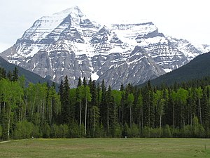
Mount Robson Provincial Park
|
Mount Robson Provincial Park
|
||
|
Mount Robson |
||
| location | British Columbia (Canada) | |
| surface | 2,252.85 km² | |
| WDPA ID | 18649 | |
| Geographical location | 53 ° 7 ' N , 119 ° 10' W | |
|
|
||
| Setup date | 1913 | |
| administration | BC parks | |
| particularities | second oldest provincial park in BC | |
The Mount Robson Provincial Park is a provincial park in the Canadian province of British Columbia . It is located in the Canadian Rocky Mountains and part of the World Heritage of UNESCO .
investment
The park is on the provincial border with Alberta and borders Jasper National Park to the west . The 2248 km² large sanctuary extends around the 3954 m high Mount Robson , the highest mountain in the Canadian Rockies. The Yellowhead Highway runs through the park over the 1146 meters high Yellowhead Pass , which forms the border with Alberta. A railway line, a pipeline and important fiber optic cables run parallel to the road through the park. The largest lake in the park area is over eleven kilometers long and up to 1.9 kilometers wide, Moose Lake , other larger lakes are Yellowhead Lake , Whitney Lake and Berg Lake . The Fraser River rises in the southwest of the park, flows through Moose Lake and tumbles over the nine-meter-high Overlander Falls .
West of the park, four kilometers before the settlement of Tête Jaune Cache, lies the 49 hectare Rearguard Falls Provincial Park, founded in 1991, with another waterfall from the Fraser River, the six-meter-high Rearguard Falls.
The park is a category II protected area ( national park ).
history
The park was founded in 1913 by a law of the British Columbia legislature and is thus the second oldest of the provincial parks in British Columbia after the Strathcona Provincial Park established in 1911 . As part of the parks in the Canadian Rockies, it has been a World Heritage Site since 1990, which also includes the Banff , Jasper, Yoho and Kootenay National Parks and the Mount Assiniboine and Hamber Provincial Parks .
Flora and fauna
British Columbia's ecosystem is divided into different biogeoclimatic zones. Biogeoclimatic zones are characterized by a fundamentally identical or very similar climate and the same or very similar biological and geological conditions. This results in a very similar population of plants and animals in the respective zones. Within the system, the park area is assigned to both the Englemann Spruce-Subalpine Fir Zone with the Moist Mild Subzone and the Sub-boreal Spruce Zone with the Dry Hot Subzone .
The lower elevations of the park are covered with mountain forests made of Douglas fir , Engelmann spruce and black spruce . Elk live in the swamps at the lower end of Moose Lake , and mule deer , white-tailed deer and black bears also live in the forests . Forest caribou , grizzly bears , mountain goats , bighorn sheep , ice gray marmots and pikas can be found in the higher elevations above the tree line and in the rocky regions . The park administration counts over 180 different bird species in the park area. The Rearguard Falls are the end of the line for many king salmon on their 1200 kilometer journey through the Fraser River to their spawning grounds in autumn .
activities
The park's visitor center is at Mount Robson Lookout on the Yellowhead Highway. There are several picnic areas and three campsites in the park. There are numerous hiking trails through the park, including the 14-mile Berg Lake Trail.
The park has 180 parking spaces (some of which can be reserved) for mobile homes and tents and has sanitary facilities with showers.
media
Caribou in Mount Robson Provincial Park
literature
- Peter Mertz: Travel Guide Nature Canada. Munich: BLV, 1996, ISBN 3-405-14817-0
Web links
- Mount Robson Provincial Park . In: BC Geographical Names (English)
- Mount Robson Provincial Park . In: English language website of the park at BC Parks
Individual evidence
- ↑ World Database on Protected Areas - Mount Robson Park (English)
- ↑ Biogeoclimatic Zones of British Columbia. British Columbia Ministry of Forests, Lands and Natural Resource Operations , accessed May 4, 2016 .
- ↑ Mount Robson Provincial Park Management Plan. (PDF; 383.88 KB) British Columbia Ministry of Environment, Lands and Parks , March 2011, accessed on March 7, 2013 .
- ^ Ecosystems of British Columbia. (PDF, 10.31 MB) British Columbia Ministry of Forests, Lands and Natural Resource Operations, February 1991, accessed March 7, 2013 .


