Hamber Provincial Park
|
Hamber Provincial Park
|
||
|
The Fortress Lake in Hamber Provincial Park |
||
| location | British Columbia (Canada) | |
| surface | 251.37 km² | |
| WDPA ID | 10452 | |
| Geographical location | 52 ° 22 ' N , 117 ° 52' W | |
|
|
||
| Sea level | from 1,335 m to 3,046 m | |
| Setup date | September 16, 1941 | |
| administration | BC parks | |
| particularities | Back Country Park | |
The Hamber Provincial Park is a provincial park in the Canadian province of British Columbia . The approximately 250 km² large reserve covers an almost untouched section of the Canadian Rocky Mountains .
The park is a category II protected area ( national park ).
geography
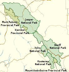
The park is located in the west of the province of British Columbia on the border with Alberta and also borders Jasper National Park there . The park is west of the continental divide , the mountains in the park are rough and glaciated. In the surrounding region are the Columbia Ice Field and the Clemenceau Ice Field .
In the park is Fortress Lake , from which the Wood River flows east to the Columbia River .
Fortress Pass is to the east of the park . At an altitude of 1,335 m , Fortress Pass is one of the lowest passes over the Canadian Rockies that is not crossed by road or rail. It is also the lowest point in the park.
At 3,046 m, Chisel Peak is the highest point in the park. North of the park boundaries is Fortress Mountain , which is approximately the same height at 3007 m .
The park is a so-called back country park as it cannot be reached via public roads. Basically, the park can only be reached on foot from the parking lot at Sunwapta Falls in Jasper National Park. From the parking lot it is 15 miles to Fortress Lake, where you have to wade through the Chaba River . The closest cities in British Columbia are Valemount to the north and Golden to the south.
history
The park was established in 1941 and named after Eric Hamber , Lieutenant Governor of British Columbia from 1936 to 1941. Originally, the park was around 10,100 km² much larger than it is today and extended as far as the Columbia River. Because large parts of this area were used for forestry and the Columbia River was dammed for energy generation, the park area was radically reduced in size in 1961. Its current limits were last set in 2004. Compared to the previous demarcation in 2000, the park grew again by around 600 hectares. Since 1975 the park has been deliberately managed as a wilderness with no essential tourist facilities.
Since 1990 he has been a part of the park in the Canadian Rockies to the World Heritage of UNESCO , which is also the national parks Banff , Jasper, Yoho and Kootenay and the Provincial Parks Mount Assiniboine and Mount Robson includes.
Flora and fauna
Within the British Columbia ecosystem, the park area is assigned to the Engelmann Spruce - Subalpine Fir Zone and the Alpine Tundra Zone . These biogeoclimatic zones are characterized by the same or a very similar climate and the same or similar biological and geological conditions. This results in a very similar population of plants and animals in the respective zones.
The vegetation in the park is dominated by alpine meadows and subalpine spruce primeval forests with Engelmann spruces , mountain hemlocks and rock mountain firs and very dense undergrowth. Wildlife includes grizzly bears , black bears , mountain goats , elk, and mule deer, as well as other species typical of the Rocky Mountains. Fortress Lake is rich in brook trout .
Tourist facilities
The park is a remote wilderness with few tourist facilities. Since the park was recognized as a world natural heritage site, the number of visitors has increased from 100 per year to around 500 per year, so that the park administration has created a simple campsite and rudimentary sanitary facilities at the east end of Fortress Lake. Because of the bears that live here, the park administration has set up a bear pole for the hikers' food. There are three more campsites on the north shore of the lake.
On Chisel Creek fan on the south shore of the lake also is a privately operated fishing camp, which is accessible by seaplane.
Web links
- Hamber Provincial Park . In: BC Geographical Names (English)
- Hamber Provincial Park . In: English language website of the park at BC Parks
- Information to the park on britishcolumbia.com (Engl.)
- Homepage of the private fishing camp
Individual evidence
- ↑ World Database on Protected Areas - Hamber Park (English)
- ↑ Chisel Peak. In: Canadian Mountain Encyclopedia . Retrieved January 4, 2013 .
- ↑ Hamber Provincial Park - Management Plan. (PDF; 2.00 MB) British Columbia Ministry of Environment, Lands and Parks , October 7, 2015, accessed on January 23, 2016 .
- ^ Ecosystems of British Columbia. (PDF; 10.31 MB) British Columbia Ministry of Forests, Lands and Natural Resource Operations , February 1991, accessed on January 4, 2013 .
- ↑ Biogeoclimatic Zones of British Columbia. British Columbia Ministry of Forests, Lands and Natural Resource Operations, accessed May 3, 2016 .


