Mount Van der Veer
| Mount Van der Veer | ||
|---|---|---|
| height | 888 m | |
| location | Marie Byrd Land , West Antarctica | |
| Mountains | Ford Ranges | |
| Coordinates | 77 ° 34 ′ 0 ″ S , 146 ° 10 ′ 0 ″ W | |
|
|
||
|
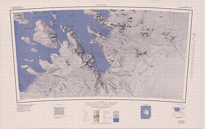
Topographic map with the Haynes Mountains and Mount Van der Veer (below center) |
||
Mount Van der Veer is a 888 m high mountain in Marie Byrd Land in West Antarctica . In the Haines Mountains of the Ford Ranges it rises 13 km southeast of Mount Ronne .
Participants in the United States Antarctic Service Expedition (1939–1941) mapped it. The Advisory Committee on Antarctic Names named him in 1966 after Willard Van der Veer (1894-1963), photographer on the first Antarctic expedition (1928-1930) of the US polar explorer Richard Evelyn Byrd .
Web links
- Mount Van der Veer in the Geographic Names Information System of the United States Geological Survey (English)
- Mount Van der Veer on geographic.org (English)

