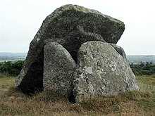
Mulfra Quoit
The Mulfra Quoit , formerly also Mulfra Cromlech , is an approximately 5500 year old dolmen from the Neolithic and is located in the county of Cornwall in England . The name is derived from the small town of the same name. The adjacent hill is Mulfra Hill .
location
The Quoit is located west of Penzance between Porthmeor and New Mill on the summit of the Mulfra Hills, from where you can look out over the surrounding hills to the sea. You can reach it on a path that branches off to the right about 3 km after Porthmeor.
construction
The Mulfra Quoit is similar to the Chûn Quoit , five kilometers away , but has been poorly preserved. On site you will find three support stones, each 1.7 m high, which border a U-shaped chamber 3.0 m long and 1.7 m wide, open on one side. On the open side, the almost square ceiling slab, which has slipped down and is 3.2 m and 3.0 m long and weighs 5 tons, leans against the supporting stones. Since some of the stones that made up the chamber are missing, it is difficult to get an idea of their original shape, but, like the Chûn Quoit, it is likely that four pillars supported the top plate. On the other hand, the cover plate has a central curvature on its underside, which would give the stone a stable position on the three existing pillars. The Mulfra Quoit was apparently covered by a hill, of the edge of which remains. Like other quoits, the megalithic complex is probably a portal grave .
Research history
In 1769, the archaeologist William Borlase published a floor plan and a drawing of the quoit and also described a 60 cm high stone embankment, which at that time encompassed the dolmen along a circle with a diameter of 12 m, of which nothing can be seen today. Borlase also mentioned another stone that he assumed was part of the top plate. This stone is no longer available today. The facility was covered by a 30 cm thick layer of earth, which led Borlase to assume that in earlier times the dolmen was inside a mound. In 1872, William Copeland Borlase , a great-grandson of William Borlase, essentially confirmed his information about a pile of stones with the dolmen in the center, and carried out excavations which, however, only yielded charred wood. WC Borlase disagreed with the view that the dolmen was destroyed by a lightning strike in 1752, because his ancestor found the facility in 1749 in the same condition as it is today. Later authors treated the Mulfra Quoit a little carelessly because of its poor degree of preservation: Hugh O'Neill Hencken described it in 1932, like the Chun Quoit, as "a huge stone box in a round hill". In 1950 Glyn Daniel mentioned little more than the name of the quoit and classified it as a "typical rectangular chamber", but at least prepared a plan of the facility.
There are other megalithic complexes nearby :
- Boscawen-ûn
- Boskednan stone circle
- Chûn Quoit
- Lanyon Quoit
- Mên-an-Tol
- Merry Maidens
- Tregeseal stone circle
- Tregiffian
- Zennor Quoit
Individual evidence
- ^ William Borlase: Antiquities Historical and Monumental of the County of Cornwall , Bowyer and Nichols, London 1769
- ^ William Copeland Borlase: Naenia Cornubiae , Longmans 1872
- ^ Hugh O'Neill Hencken: The Archeology of Cornwall and Scilly , Metheun 1932
- ^ Glyn Edmund Daniel: The Prehistoric Chamber Tombs of England and Wales , Cambridge University Press 1950
literature
- Ian McNeil Cooke: Standing Stones of the Land's End . Cornwall: Men-an-Tol Studio 1998, ISBN 0951237195 .
Web links
Coordinates: 50 ° 9 ′ 47.7 " N , 5 ° 34 ′ 8.7" W.

