Municipio of San Miguel de Allende
| San Miguel de Allende | ||
|---|---|---|

|
||
| Symbols | ||
|
||
| Basic data | ||
| Country | Mexico | |
| State | Guanajuato | |
| Seat | San Miguel de Allende | |
| surface | 1,558.1 km² | |
| Residents | 160,383 (2010) | |
| density | 102.9 inhabitants per km² | |
| Website | sanmiguelallende.gob.mx | |
| INEGI no. | 11003 | |
| politics | ||
| Presidente municipal | Ricardo Villarreal García | |
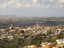
| View of the city of San Miguel de Allende and the surrounding area | ||
Coordinates: 20 ° 51 ′ N , 100 ° 50 ′ W
San Miguel de Allende , until 2005 Allende , is a municipality in the Mexican state of Guanajuato . The municipality covers an area of 1558.1 km². In 2010, San Miguel de Allende had a population of 160,383 people. The administrative seat and most populous place of the municipality is the UNESCO World Heritage city of San Miguel de Allende .
geography
The municipality is located in a region known as Bajío at an altitude between 1700 m and 2900 m . Almost 84% of the municipality belong to the physiographic province of the Mesa del Centro , the rest to the Sierra Volcánica Transversal . The municipal area drains over the Río Lerma into the Pacific Ocean . In the municipality is the reservoir of Presa Ignacio Allende .
About 44% of the geology of San Miguel de Allende is occupied by volcanic rocks with about 37% sediments and sedimentary rocks and 15% alluvial soils ; The predominant soil types are the Phaeozem (40%) and the Vertisol (36%). More than 40% of the municipality's area is used for arable farming, a further 35% is used as pasture land, and almost 15% is taken up by forests.
The municipality of San Miguel de Allende borders the municipalities Dolores Hidalgo Cuna de la Independencia Nacional , San Luis de la Paz , San José Iturbide , Apaseo el Grande , Comonfort , Santa Cruz de Juventino Rosas and Salamanca as well as the state of Querétaro .
population
The 2010 census counted 160,383 people in 35,408 residential units in the municipality. Of these, 629 people were registered as speakers of an indigenous language , including 298 speakers of the Otomí and 106 speakers of the Nahuatl . Almost 12 percent of the population were illiterate. 57,733 inhabitants were registered as economically active, of which approx. 67% were men and 7.4% were unemployed. 21% of the population lived in extreme poverty.
places
The Municipio Acámbaro comprises 512 inhabited localidades , of which, in addition to the main town, Los Rodríguez and Colonia San Luis Rey are classified as urban by the INEGI . In the 2010 census, 19 places had a population of over 1000, 116 other places had at least 200 inhabitants. The largest places are:
| place | Residents |
| San Miguel de Allende | 69,811 |
| Los Rodríguez | 2,773 |
| Colonia San Luis Rey | 2: 707 |
| Corral de Piedras de Arriba | 2,037 |
| Rancho Viejo | 2,001 |
| Santa Teresita de Don Diego | 1,487 |
| Los Galvanes | 1,364 |
| Puerto de Nieto | 1,305 |
| La Cieneguita | 1,241 |
| Alcocer | 1,224 |
| Clavellinas ( Clavellinas Coyotes ) | 1,152 |
| Nigromante | 1,144 |
| Guadalupe de Támbula | 1,056 |
| Sosnabar | 1,035 |
| Corralejo de Arriba | 1,026 |
| Cerritos | 1,015 |
| Don Francisco | 1.010 |
| La Cruz del Palmar | 1.009 |
Web links
- Enciclopedia de los Municipios y Delegaciones de México: Municipio San Miguel de Allende (Spanish)
- INEGI : Datos Geográficos: Municipio San Miguel de Allende (Spanish; PDF)


