
Nürnberger Platz (Dresden)
| Nürnberger Platz | |
|---|---|
|
|
|
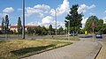
 Nürnberger Platz, view towards Fritz-Förster-Platz |
|
| Basic data | |
| place | Dresden |
| District | Südvorstadt |
| Created | 19th century |
| Newly designed | planned, should be completed by 2025 |
| Confluent streets | Nürnberger Strasse , Münchner Strasse , Hettnerstrasse, |
| Buildings | Technical University |
| use | |
| User groups | Pedestrian traffic , bicycle traffic , public transport , car traffic |

The Nuremberg court in Dresden is located in the Südvorstadt and is a crossing point of the Münchner Straße and Nürnberger Straße . As part of the Outer City Ring, the latter is an important link in the south of the city. It runs between the western and eastern parts of Dresden above the main train station. The Münchner Straße leading out of the city from Fritz-Löffler-Platz, first Reichsplatz, then Juri-Gagarin-Platz, crosses Nürnberger Straße here. The original circular version of the development area before the First World War can only be traced back to the street edges due to the destruction in 1945 and the subsequent clearing of rubble.
Location and development
Nürnberger Platz above the Swiss Quarter in Dresden is a central square in the southern suburbs. It is the important intersection of Münchner Strasse and Nürnberger Strasse. The only other street going out is Hettnerstraße in the direction of the Technical University . Between 1904 and 1910, groups of buildings with richly decorated sandstone facades with elements of Art Nouveau were built around the circular square in a lively development . The four to five storey houses formed a closed ensemble in their unit. Shops, individual agencies and locations were set up on the ground floors. In addition to students and members of the Technical University, civil servants, lawyers, tradespeople and artists with their own studios lived in this place.
history
Before 1945


In the area of today's Nürnberger Platz, roughly in the triangle that is formed today by Nürnberger, Münchner and Bergstrasse, was the Auswick Vorwerk. Mentioned for the first time around 1350, the council of Dresden bought the Vorwerk in 1455 , had it removed and the fields distributed to Dresden residents. Excavations near the former village of Boskau , near today's St. Luke Church , prove that the Slavs settled in this area a thousand years ago . Further west at the Vorwerk Auswick, for example in the area of the later post office 32, in the hilly lands of the later potato and corn fields and meadows, there were also gardens as part of the later Dresden Südvorstadt .
Today's Bergstrasse is an important connection to the Ore Mountains . The Münchner Straße branches off at Fritz-Löffler-Platz as a connection to the higher southern buildings and manors of the city. Nürnberger Platz was built around 1899 above the Swiss Quarter in Dresden as the central square of the Bavarian Quarter . As a tribute, the other streets in the residential area above Eisenstuckstraße were also named with Bavarian city names. In order to emphasize the new city quarter, the Nürnberger Platz was created in the local law of the development planning Old Town-Southwest of the Dresden City Council on April 13, 1899. The development plan was approved by the Lord Mayor of Dresden Otto Beutler and appeared in the Dresdner Anzeiger on June 10, 1899 .
The actual development began in 1904, primarily by the Dresden construction company . This had already acquired large parts in advance and also traded in building plots. However, there was also resistance to the construction work, which was mainly from the residents of the northern Swiss quarter. They feared the loss of the good air and the depreciation of their properties. Originally an Evangelical Lutheran church was also planned on Nürnberger Platz, later this was to be built on Nürnberger Ei and was finally built around 1912 by a donor as the Zionskirche on Nürnberger Straße, corner of Hohe Straße.
After 1945

The major air raids on Dresden reached their climax between February 13 and 15, 1945 , destroying 80% of the buildings in the southern suburb and killing over 6,000 people in this area. The entire development on Nürnberger Platz was destroyed between 10:13 p.m. and 10:28 p.m.
From the end of the 1940s, the Dresden rubble railway, coming from the city center, ran the Südvorstadt in this area. The direct clearing of rubble from the southern suburb only began at the end of 1951 and was largely completed in August 1952. Trümmerbahn 4 ran on Kaitzer Strasse, Bamberger Strasse via Münchner Platz to Lehmgrube Nöthnitzer Strasse. This had a capacity for 1.2 million cubic meters of rubble.
The actual Nürnberger Platz initially remained undeveloped. In the adjacent Rugestrasse, the former Bendemannstrasse, a university bookstore , now the Thalia bookstore, Technical University, was built. To the east of this, in the 1960s, an eight-story residential building was built using monolithic brick construction with the Helmholtz pharmacy on the ground floor, one of four buildings of this type that were built in Dresden. Today's Potthoff building of the Technical University of Dresden was built in the southeast in the 1950s, to the northeast it remained until well into the 2000s with several barracks that were built as “temporary structures” for the Technical University and were used by the Technical University until the 2000s . Otherwise, after it was cleared, Nürnberger Platz only offered green and fallow areas.
After 2016
The city of Dresden is planning a new urban development version for Nürnberger Platz: The round area is to be framed with eight-story buildings as an urban square with the character of a city gate, according to the development plan No. 3014 Dresden-Altstadt ll No. 28 Quartier am Nürnberger Platz from 18. May 2016 . The first building in the south-west boundary of the square was completed in 2019, it is a high-rise, taking up the urban dominant feature on the south-west corner of the square from before 1945 and includes a student dormitory with 312 beds in 289 apartments. The ground floor offers space for cafes and shops.
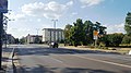
Nürnberger Platz viewed from Münchner Strasse
Nürnberger Platz viewed from Nürnberger Strasse

Nürnberger Platz View into Hettnerstrasse

View of Münchner Strasse, student dormitory


Junction for local public transport
Nürnberger Platz is also an important transfer point for local public transport. On October 22, 1900, the Dresden tram company ("Yellow") opened the first tram line that ran across Nürnberger Platz. Electrically operated, it ran from Reichsplatz along the entire Münchner Strasse to Nöthnitzer Strasse in Plauen . On October 1, 1913, the branch line from Nürnberger Platz to Nürnberger Ei was opened.
The heavy destruction in 1945 meant that tram traffic across the square was not possible again until December 12, 1946. Over the decades, since 1909, the year the line numbers were introduced, (at some point) the lines 1, 2, 3, 4, 5, 6, 8, 10, 11, 15, 16 served Nürnberger Platz in regular operation, plus the Emergency or commuter traffic lines S 15, 55, 56, E and E3.
Urban bus traffic existed on Nürnberger Platz from August 9, 1925: The later line A ran from Neustädter Bahnhof via Hauptbahnhof - Münchner Straße - Nürnberger Straße to Löbtau and was later supplemented by lines J and F, so that an emergency vehicle before the second World War there was a 4-minute train of cars in rush hour on this bus route (and thus on Nürnberger Platz). Bus traffic ended on December 4, 1941.
In the course of Nürnberger Straße, the first and only trolleybus line in Dresden was operated, which also served Nürnberger Platz from January 2, 1958 and was present there until July 15, 1974. The route number 61 , which was assigned to the trolleybus in 1964 , still carries the bus route that serves its route today.
The DVB stops are also served by bus route 333 from the Saxon Switzerland-Eastern Ore Mountains regional traffic (RVSOE).
Today's lines (as of summer 2019) are:
| No. | End point | Means of transport | Route | End point | length | Travel time |
|---|---|---|---|---|---|---|
| 3 | Coschütz | tram | Plauen - Nürnberger Platz - Central Station - Albertplatz - Neustadt Station | Wild man | 11.9 km | 38 min |
| 8th | Hellerau | tram | Albertplatz - Postplatz (Zwinger) - Prager Straße - Central Station - Nürnberger Platz | Südvorstadt | 13.3 km | 39 min |
| 61 | Whitish | City bus | Bühlau - Loschwitz - Schillerplatz - Zwinglistraße - Strehlen - Nürnberger Platz | Löbtau | 20.2 km | 63 min |
| 333 | Dresden | Regional bus | Nürnberger Platz - Kesselsdorf - Wilsdruff - Mohorn - Nürnberger Platz | Hetzdorf |
Far-reaching traffic plans for local public transport are available and are to be implemented after 2020: From the central tram stop Kesselsdorfer Straße at Drei-Kaiser-Hof in Löbtau , a continuation of the tram route over the Nossener Bridge to Nürnberger Platz with a connection to the main train station is planned. Another construction stage is to lead from here via Zellescher Weg to the Dresden Strehlen S-Bahn station .
literature
- Dresden address book 1944, p. 406. online SLUB. http://digital.slub-dresden.de/werkansicht/dlf/406/507/cache.off
- Annette Dubbers , Jenni Dubbers, Bertram Fuhg, Friedrich Karl Fromme: Südvorstadt. From the history of a Dresden district. Michel Sandstein, Dresden 1996, ISBN 3-937 199-32-2 . P. 42ff
- Fritz Löffler : The old Dresden - history of its buildings. Seemann-Henschel, ISBN 3-363-00007-3 .
- Michael Lenk and Ralf Hauptvogel: The Dresden rubble railways. Special issue B August 1999 from Verein e. V. Historical light railway Dresden.
- Walter May, Werner Pampel, Hans Konrad: Architecture Guide GDR - Dresden District. VEB Verlag für Bauwesen, Berlin 1979, p. 48.
- Matthias Lerm: Farewell to old Dresden: Loss of historical building stock after 1945. Hinstorff-Verlag, Rostock 2000, ISBN 3-356-00876-5 .
- Dirk Hein: Nürnberger Platz is facing a radical change! Day 24 of February 5, 2018
Web links
- Vorwerk Auswick
- Hantzsch: Name book of the streets and squares of Dresden. Baensch, Dresden 1905, series of publications by the Society for the History of Dresden, 17/18.
- Overview of the construction projects at Dresdner Postplatz (SZ, January 2018)
- Address book 1920
- Dresden districts
- Dormitory
- Day24
- Zoning plan Nürnberger Platz
- Stadtbahn-Dresden-2020
- Development plan No. 3014 Dresden-Altstadt II No. 28 quarters on Nürnberger Platz
Individual evidence
- ^ Annette Dubbers (Ed.): The south suburb. From the history of a Dresden district. With the participation of Jenni Dubbers, Bertram Fuhg, Friedrich Karl Fromme. Michel Sandstein, Dresden 1996, ISBN 3-937 199-32-2 , p. 5.
- ↑ a b Annette Dubbers (ed.): The south suburb. From the history of a Dresden district. With the participation of Jenni Dubbers, Bertram Fuhg, Friedrich Karl Fromme. Michel Sandstein, Dresden 1996, ISBN 3-937 199-32-2 , pp. 42-44.
- ↑ Michael Lenk and Ralf Hauptvogel: The Dresden rubble railways. Special issue B August 1999 from Verein e. V. Historic Feldbahn Dresden, p. 54.
- ↑ Student residence. Thomas Müller, van Reimann, accessed on August 8, 2019 .
- ↑ Dirk Hein: NÜRNBERGER PLATZ IS IN FRONT OF A RADICAL CHANGE Day 24 on February 5, 2018, accessed on August 8, 2019.
- ↑ Development plan no. 3014 Dresden-Altstadt II no. 28 Quarters at Nürnberger Platz - Quarters at Nürnberger werk = civic participation portal. State of Saxony, accessed on August 8, 2019 .
- ^ Mario Schatz: Tram to Südvorstadt (Nürnberger Strasse). In: Tram Museum Dresden (Ed.): The bell - information newspaper of the Association of Tram Museum Dresden e. V. Edition 57 (March 31, 2017), pp. 22–27, here p. 22.
- ^ Mario Schatz: Tram to Südvorstadt (Nürnberger Strasse). In: Tram Museum Dresden (Ed.): The bell - information newspaper of the Association of Tram Museum Dresden e. V. Edition 57 (March 31, 2017), p. 22–27, here p. 22. The information in DVB: From coachmen and conductors. The 135-year history ... , p. 91, with 1924 is wrong.
- ^ Mario Schatz: Tram to Südvorstadt (Nürnberger Strasse). and Volkmar Oppe: In the 50s - The 50s lines . In: Tram Museum Dresden (Ed.): The bell - information newspaper of the Association of Tram Museum Dresden e. V. Edition 57 (March 31, 2017), pp. 22–27 and pp. 29–32.
- ^ Mario Schatz: Tram to Südvorstadt (Nürnberger Strasse). In: Tram Museum Dresden (Ed.): The bell - information newspaper of the Association of Tram Museum Dresden e. V. Edition 57 (March 31, 2017), pp. 22–27, here p. 24.
- ↑ Stadtbahn-Dresden-2020. Dresden, accessed on August 8, 2019 .
Coordinates: 51 ° 1 '54.6 " N , 13 ° 43' 37.2" E