
Matsalu National Park
| Matsalu National Park | |||
|---|---|---|---|
|
|||
| Location: | Estonia | ||
| Next city: | Lihula | ||
| Surface: | 486.1 km² | ||
| Founding: | 2004 | ||

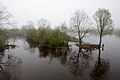
The Matsalu National Park is located in western Estonia . Its area is 486.1 km². It includes the area around the Bay of Matsalu , the surrounding land areas, the lower reaches of the Kasari River and the species-rich sea area Väinameri with over 50 islands.
area
The Matsalu nature reserve was founded in 1957, enlarged considerably in 2004 and upgraded to a national park. Today it also includes the nature reserves of Puhtu-Lahelatu and Nehatu and the nature reserves of Tuhu and Lihula. In 2003 the Matsalu National Park was awarded the “ European Diploma for Protected Areas ” by the Council of Europe .
The administrative center is located in Penijõe village , 3 km from Lihula ( Pärnu County ).
Flora and fauna
The national park was established primarily as a sanctuary for the numerous bird species. Today 275 different bird, 49 fish and 47 mammal species are recorded. There is also a rich flora with 772 plant species, some of which are rare.
Islands
The national park is also known for its impressive island world. The largest islands are Tauksi , Liia, Sõmeri, Kumari, Papilaid, Sipelgarahu and Tondirahu.


Barnacle geese

Kumari

Puisenina
Kasari
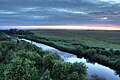
Kasari


literature
- Matsalu laiud, luhad yes linnud . Tallinn , 1962 .
- Matsalu - rahvusvahelise tahtsusega märgala . Tallinn , 1985 .
- Florian Bibelriether: Palju õnne sünnipäevaks, Matsalu! In: National Park . No. 126 , 2004, pp. 34–39 (The title means happy birthday, Matsalu ! , the article is written in German).
Web links
- National park website (Estonian, German and English)
- Directory of bird species in the national park
- National park map
- Pictures and articles (eng) about the national park
- Boulders in the National Park