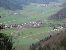
Neubrunn (Turbenthal)
| Neubrunn | ||
|---|---|---|
| State : |
|
|
| Canton : |
|
|
| District : | Winterthur | |
| Political community : | Turbenthal | |
| Postal code : | 8488 | |
| former BFS no. : | 0228 | |
| UN / LOCODE : | CH TUR (Turbenthal) | |
| Coordinates : | 709 814 / 255 397 | |
| Height : | 608 m above sea level M. | |
| Residents: | 100 | |
|
Proportion of foreigners : (residents without citizenship ) |
20.3% (December 31, 2018) | |
| Website: | www.turbenthal.ch | |
| map | ||
|
|
||
Neubrunn is a village with about 100 inhabitants that belongs to the municipality of Turbenthal in the Töss Valley in the Swiss canton of Zurich . It lies at a height of 608 meters above sea level between the villages of Oberhofen and Seelmatten, which also belong to the municipality of Turbenthal.
The Chatzenbach, which rises in Neubrunn and flows into the Töss in Turbenthal, flows through the village . In Neubrunn there is a primary school and the Krone economy. The coat of arms shows a red griffin or dragon on a yellow background.
The village was an exclave of the Greifensee rule until around 1798 . Neubrunn is already marked on Hans Conrad Gyger's "Map of the Canton of Zurich" from 1667.
- ↑ Data on the resident population by home, gender and age (community profile). Statistical Office of the Canton of Zurich, accessed on December 22, 2019 .


