New crops
| New crops | |
|---|---|
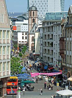
| Street in Frankfurt am Main | |
| View from Römerberg towards Liebfrauenberg | |
| Basic data | |
| place | Frankfurt am Main |
| District | Old town |
| Created | 12th Century |
| Connecting roads | Liebfrauenstrasse, Bleidenstrasse, Töngesgasse (N), Römerberg , Braubachstrasse (S) |
| Cross streets | Liebfrauenberg , Berliner Strasse , Braubachstrasse |
| Buildings | House of Paradise, Old Stock Exchange (†) |
| Technical specifications | |
| Street length | 170 m |
The Neue Kräme is an important street in the old town of Frankfurt am Main . It connects two important squares in a south-north direction, the Römerberg and the Liebfrauenberg with the striking Liebfrauenkirche . Its northern continuation, Liebfrauenstrasse, has led to the Zeil shopping street and Hauptwache since 1855 . Before this road breakthrough , there was no connection between the old town and the new town along the former Staufen wall between the Friedberger Pforte and the Bockenheimer Pforte (near the Katharinenkirche ) .
location
Within the densely built-up old town, the Neue Kräme was one of the three most important north-south connections. It connected the two largest squares in the old town, the Liebfrauenberg with the Römerberg and further with the Fahrtor on the banks of the Main to the south and the port there. The other north-south connections were the Fahrgasse running east of the cathedral , which ran from the Bornheimer Pforte near today's Konstablerwache to the Main Bridge , and the western Kornmarkt between the Bockenheimer Pforte ( also called Katharinenpforte after the church that was later built there ) and the Leonhardstor next to the Leonhardskirche am Main.
history
The name refers to the fact that the street was used as a marketplace, dishes and glasses were offered here during medieval fairs . The Gothic halls on the first floor of the Römer served as the central exhibition hall, while the nearby Nürnberger Hof and the Stone House, among others, served as quarters for the merchants.
The urban environment changed considerably in the 19th and 20th centuries. First of all, to the west of the street, instead of the old Barfüßerkirche and a cemetery, the Paulskirche (completed in 1833) and a (for the time) large, representative town square, Paulsplatz . Another important building was erected between Paulsplatz and Neuer Kräme, the stock exchange .
In the years 1904 to 1906 another road breakthrough, Braubachstrasse , was laid through the old town from east to west in order to make it accessible with modern means of transport (such as the electric tram ). The small Wedelgasse that had previously led to Paulsplatz disappeared, and instead of the striking funnel-shaped confluence with the Römerberg, there was now a wide street to be crossed. In addition to the closed street scene, the greater part of the Nürnberger Hof also fell victim to the new street, which, however, with its magnificent commercial buildings and the extension of the town hall, became one of the largest construction projects of these years.
On March 22, 1944, an Allied air raid destroyed the old town almost completely. In the Neue Kräme, however, some more massive commercial buildings from the early days of the company survived the destruction. After the end of the war, the city administration planned a reconstruction based on the principles of modern urban planning . Another traffic lane was laid north parallel to the first. In contrast to Braubachstrasse, the four-lane Berliner Strasse , which was created instead of the narrow Schnurgasse, is primarily used for car traffic. It leads north past the Paulskirche and "enriches" the path from Liebfrauenberg to Römerberg with another road crossing. The destroyed street block between Paulsplatz and Neuer Kräme, the location of the old stock exchange, was not rebuilt, so that the Neue Kräme today forms the east side of the enlarged Paulsplatz.
The Neue Kräme has been a pedestrian zone since 1968 and an important shopping street with some well-known specialist shops . In contrast to other Frankfurt shopping streets, the proportion of chain stores is very low. The section at Paulsplatz is used by several street cafes in summer. In winter, the Frankfurt Christmas market stretches along the entire length of the street from Römerberg via Paulsplatz to Liebfrauenberg. As a connection between the Schnellbahn junction at the Hauptwache and the tourist attractions of the old town, the Neue Kräme now also plays an important role for inner-city pedestrian traffic.
- See also : Sketch of the location of the two road openings in the article Nürnberger Hof .
Web links
swell
- ↑ Stadtvermessungsamt Frankfurt am Main (ed.): Portal GeoInfo Frankfurt , city map
Coordinates: 50 ° 6 ′ 43 ″ N , 8 ° 40 ′ 54 ″ E


