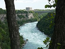
Niagara Gorge
Coordinates: 43 ° 7 ′ 15 " N , 79 ° 4 ′ 14" W.

The Niagara Gorge ( English Niagara gorge [ naɪˌæɡ (ə) ɹə ˈɡɔɹd͡ʒ ]) is an 11 km long gorge that is formed by the Niagara River along the Canadian - American border between the US state of New York and the Canadian province of Ontario . It begins at the foot of the Niagara Falls and ends at the Niagara Layer near Queenston , Ontario, where the falls were formed about 12,500 years ago.
Over time, the waterfalls have migrated further upstream towards Lake Erie due to the so-called retrograde erosion . This is due to the hard surface rock made of Lockport dolomite and the softer layers below. The latter are hollowed out by the masses of water until the slightly eroded dolomite plate above is no longer supported and breaks.
The river current in the canyon is one of the most powerful in the world. The rapids of the gorge have already claimed many lives. Kayaking in the gorge is therefore now generally prohibited. Occasionally, however, world-class canoeists were allowed to navigate the route.
Tourists can cruise the rapids of the Niagara Gorge on commercial tours in rugged watercraft. These start in Niagara-on-the-Lake , Ontario, Lewiston , New York, and in mid-summer at the Niagara Glen Nature Center on the Niagara Parkway in Ontario.
Individual evidence
- ^ Niagara Parks: Niagara Falls Geology Facts & Figures " Retrieved January 14, 2020