Nightcap range
| Nightcap range | ||
|---|---|---|
|
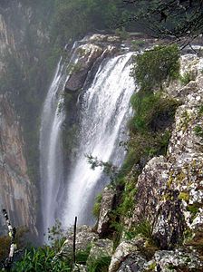
Minyon Falls |
||
| Highest peak | Mount Burell ( 933 m ) | |
| location | New South Wales | |
| part of | Great dividing range | |
|
|
||
| Coordinates | 28 ° 33 ′ S , 153 ° 20 ′ E | |
| rock | Basalt and rhyolite | |
The Nightcap Range is a mountainous country in northern New South Wales in Australia , 35 kilometers north of Lismore and 120 kilometers south of Brisbane . Nightcap National Park and the Whian Whian State Conservation Area stretch across the mountains .
history
Originally the Wiljabullan clan of the Buldjalung Aborigines lived in the area of the Nightcape Range . The first Europeans invaded this area as early as 1830. It was loggers who mainly felled the Australian red cedar ( Toona ciliata ). In the years 1976 to 1979 conservationists were committed to preventing deforestation. This enabled the Nightcap National Park to be enforced and placed under nature protection in 1983. 5000 hectares of the Nightcap Range are now considered part of the Gondwana Rainforests reported, a UNESCO - World Heritage .
nature
The Nightcap Range is located on the southern edge of the Mount Warning shield volcano , from which lava flowed for long periods of time and which ejected rhyolite in its explosive phase . The soils of the Nightcap Range are weathered products of rhyolite and basalt . They formed the basis for abundant vegetation, which was favored by a subtropical climate and heavy rainfall. The Nightcap Range has the highest rainfall in the state of New South Wales. A subtropical rain forest was created, in which there is a rich flora and fauna.
520 plant and 276 animal species have been discovered in the flora and fauna, 36 of which are endangered. Due to the diversity of bird species, the entire Nightcap Range has been listed as the Nightcap Range Important Bird Area . This bird sanctuary covers 157 square kilometers in northeast New South Wales, including the Northcap Range.
Several hiking trails lead through the Nightcap Range.
Mountains and waterfalls
In the Nightcap Range there are several mountains such as Mount Burrell (Blue Knob) at 933 meters, Mont Neville at 919 meters and Mount Nardi at 812 meters above sea level.
Mighty waterfalls cascade over cliffs like the Minyon, Quandong and Protestor Falls.
Individual evidence
- ↑ a b c Nightcap National Park and Whian Whian State Conservation Area
- ↑ Gay Dutson et al: Australia's Important Bird Areas , p. 27, October 2009. Retrieved July 18, 2018

