Niutao
| Niutao | ||
|---|---|---|
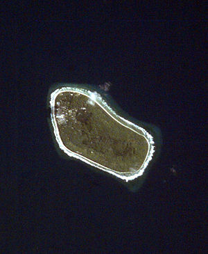
| NASA image of Niutao | ||
| Waters | Pacific Ocean | |
| Archipelago | Ellice Islands | |
| Geographical location | 6 ° 6 ′ 31 ″ S , 177 ° 20 ′ 33 ″ E | |
|
|
||
| length | 2.6 km | |
| width | 1.2 km | |
| surface | 2.53 km² | |
| Residents | 606 (2012) 240 inhabitants / km² |
|
| main place | Kulia | |
| Children on Niutao | ||
Niutao is an island in the Pacific Ocean and part of the state of Tuvalu . The 2.53 square kilometer island forms together with Niulakita one of the eight administrative districts ( Falekaupule ) of the country (see Niutao (district) ). 606 inhabitants (as of 2012) live in two villages on Niutao. The main town with 406 inhabitants (2012) is Kulia (historically probably Tuapa ) on the southwest coast of the island . Immediately to the south-east of this is the village of Teava (historically probably Angafoulua ), about half as large with 200 inhabitants (2012) . In 1949, some residents moved to Niulakita Island due to overpopulation.
geography
Niutao is an upscale atoll on which a new fringing reef has formed. The remnants of the central lagoon are a shallow brackish lake and a pond in the northwest of the island. Today the lake is spanned by a road that opens up the coconut plantations in the northern area of the 2.6 km long and 1.2 km wide island.
Discovery story
The Spanish navigator Francisco Mourelle de la Rúa (1750 - 1820) discovered Niutao for Europe on May 5, 1781. He did not enter the island, however, but his ship La Princesa stayed outside the coral reef when several canoes approached with islanders who gave the crew coconuts. Mourelle then named the island "El Gran Cocal". In 1825 the American captain Obed Starbuck (1797 - 1882) named the island "Loper's Island" after his whaling ship Loper . In 1836 another whaler, Captain William Plaskett of Nantucket , arrived on the island in his ship Independence II . Since he noticed the faces of the warriors dyed black with charcoal, he called them "Smut-Face Island". Other old names for Niutao are "Speider Island" and "Lynx Island".
Infrastructure
The island is surrounded by an unpaved ring road. Next to the lagoon there are at least two fountains on Niutao. There is also a hospital, school, post office and cemetery on the island.
Web links
- Niutao in the GeoNames database
- History of the island (English)
- Map of Niutao
Individual evidence
- ^ Falekaupule Act. Government of Tuvalu, 1997, No. 8; 2008 revised edition, CAP. 4.08, Schedule 1, p. 56, accessed on July 29, 2014
- ^ Tuvalu Online GIS. Tuvalu Central Statistics Office, January 2015, accessed January 8, 2015 .
- ↑ a b Map of Niutao. TuvaluIslands.com, date unknown retrieved July 30, 2014
- ^ Keith S. Chambers and Doug Munro: The Mystery of Gran Cocal: European Discovery and Mis-Discovery in Tuvalu. The Journal of the Polynesian Society, Volume 89 (2) 1980, pp. 167-198
- ^ Henry Evans Maude : Post-Spanish discoveries in the Central Pacific . In: The Journal of the Polynesian Society, Vol. 70, Auckland 1961, pp. 67-111
- ↑ Simati Faaniu, Hugh Laracy (Ed.): Tuvalu - A History. Institute of Pacific Studies, University of the South Pacific, Suva 1983, p. 102
- ↑ Pacific Islands Pilot (Volume 2). United States Hydrographic Office, Washington 1916, p. 409


