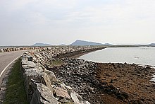
North Ford

The North Ford is a strait that separates the Scottish Hebridean islands of Benbecula in the south from the neighboring island of North Uist in the north . The waterway runs in an east-west direction and is about four kilometers wide at its widest point at the western end. At its narrowest point, it measures around 2.5 km. It stretches for twelve kilometers between the islands of Grimsay in the east and Baleshare in the west.
The North Ford is a shallow waterway with numerous small islands and rocks. It is subject to the tides and can be crossed on foot for a few hours at low tide. In order to create a traffic connection between Benbecula and North Uist, a traffic dam was planned over the North Ford. Due to the shallow water, the establishment of a ferry connection was out of the question. After three years of construction, the North Ford Causeway was finally opened on September 17, 1960 in the presence of the British Queen Mother . 350,000 t of rock material were required to build it . At times up to 90 workers were employed. The North Ford Causeway leads the A865 from Benbecula via Grimsay to North Uist. It is the longest of the dams that connect the islands of the Uist group .
Individual evidence
- ^ Entry in the Gazetteer for Scotland
- ↑ Entry on cne-siar.gov.uk ( Memento of the original from December 10, 2014 in the Internet Archive ) Info: The archive link was inserted automatically and has not yet been checked. Please check the original and archive link according to the instructions and then remove this notice.
- ↑ Isles' North Ford Causeway reaches 50th anniversary , BBC News, Sep. 6, 2010.
Coordinates: 57 ° 30 ′ 0 ″ N , 7 ° 19 ′ 0 ″ W.
