Baleshare
| Baleshare | |
|---|---|
| The west coast of Baleshare when the tide sets in; in the background North Uist. | |
| Waters | Atlantic Ocean |
| Archipelago | Outer Hebrides |
| Geographical location | |
| length | 4.4 km |
| width | 3.3 km |
| surface | 9.1 km² |
| Highest elevation | 15 m |
| Residents | 58 (2011) 6.4 inhabitants / km² |
| main place | Samala |
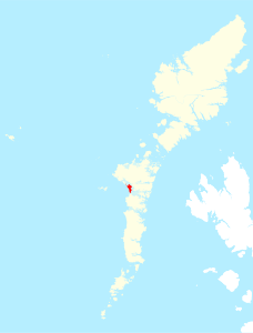
Baleshare ( Scottish Gaelic : Baile Sear ) is a Scottish island. It is located only a few hundred meters west of North Uist and north of Benbecula and belongs to the Outer Hebrides archipelago , or administratively to the council area of the same name . Historically, Baleshare was part of the county of Inverness-shire .
geography
The maximum north-south extension is about 4.4 km, the width at most 3.3 km, with a total area of 9.1 km 2 . The highest point of the flat island rises 15 m above sea level. Baleshare marks the western terminus of the North Ford , which flows along the east coast. In the south, the bump on Toim Baleshare borders on neighboring Benbecula. The Atlantic Ocean crashes on the west coast . At low tide, the North Ford between Baleshare and North Uist falls dry and can be crossed on foot. In contrast, the Beul on Toim in the south carries water even at low tide. An area in the north of the island is called Illeray . It used to be a separate island with this name, but it merged with Baleshare in the 19th century. Although Francis H. Groome still describes Illeray as separate islands in the 1880s, the 1861 census summarized both islands, treating them separately in the 1851 and 1841 censuses.
population
58 people live on the sparsely populated Baleshare (as of 2011). These are mainly divided between two settlements, Samala on the east coast and Teanamachar on the west coast. As in most of the Scottish islands, the population has decreased significantly in recent times. In 1861, 199 people lived in 35 houses on Baleshare and Illeray (1851: 204). The Baleshare Causeway , built in 1962, is ascribed an important role in the moderate population decline on the small island. This is a 350 m long dam to North Uist, which is the only paved traffic route from the island. He leaves the island near Samala.
Individual evidence
- ↑ a b Entry in the Gazetteer for Scotland
- ↑ Balleshare. In: Francis H. Groome: Ordnance Gazetteer of Scotland: A Survey of Scottish Topography, Statistical, Biographical and Historical. Volume 1: (A - Coru). Thomas C. Jack, Grange Publishing Works, Edinburgh et al. 1882, p. 114 .
- ↑ Hamish Haswell-Smith: The Scottish islands. A comprehensive guide to every Scottish Island. Fully revised 2nd edition. Cannongate, Edinburgh et al. 2004, ISBN 1-84195-454-3 .
- ^ Map of the Ordnance Survey
- ^ Entry in the Gazetteer for Scotland
- ↑ a b Entry in the Gazetteer for Scotland
- ^ Entry in the Gazetteer for Scotland
- ^ A b Scotland Census Office: Census of Scotland – 1861. Population Tables and Report. Number of the Inhabitants, Families, Children at School, Houses, and Rooms with Windows, in the Civil Counties and Parishes, Registration Counties and Districts, Burghs, Towns, Villages, and Islands of Scotland: Also a Classification of Families according to their Sizes , the Number of Persons they Contain, and their relative House Accommodation. Murray and Gibb for Her Majesty's Stationery Office, Edinburgh 1862, p. 6 , p. 19 .
- ↑ 2011 census data
- ^ Entry in the Gazetteer for Scotland
- ↑ Entry on cne-siar.gov.uk ( Memento from February 22, 2014 in the Internet Archive )
- ^ Robert Emmott, Tim Pickering and Mike Sullivan: The Outer Hebrides. Sea Kayak Journeys to the Isles & St Kilda. Pesda, Caernarfon 2010, ISBN 978-1-906095-09-3 , p. 142.


