Barra (island)
| Barra | |
|---|---|
| Bay of Castlebay with town, harbor and castle | |
| Waters | North Atlantic |
| Archipelago | Outer Hebrides |
| Geographical location | 56 ° 59 ′ 0 ″ N , 7 ° 28 ′ 0 ″ W |
| surface | 58.75 km² |
| Highest elevation | Heaval 384 m above sea level NN |
| Residents | 1174 (2011) 20 inhabitants / km² |
| main place | Castlebay |
Barra ( Scottish Gaelic : Barraigh ) is the largest island in the south of the Outer Hebrides in Scotland .
geography
Vatersay (Scottish Gaelic: Bhatarsaigh ) is the only inhabited island in the vicinity of Barras , which can be reached via a dam from Barra. A number of smaller islands that have been uninhabited since the beginning of the 20th century can be reached by boat and are sometimes used as sheep pastures during the summer . South of Barra is the island of Barra Head (also called Berneray) with the southernmost point of the same name in the Outer Hebrides.
Most of the approximately 1200 inhabitants of Barra live in the only village on the island, Castlebay (Scottish Gaelic: Bàgh a 'Chaisteil ) on the south coast of Barra. The place extends along a bay. Most of the other settlements are also on the coast.
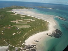
Barra is characterized by a central mountain range with the 384 meter high Heaval as the highest point. The mountains are mostly covered by peat . The coastal areas are partly rocky cliffs, partly fertile Machair areas with high sand dunes and wide beaches.
Culture and economy
The majority of the population is Catholic and lives mainly from agriculture (especially extensive sheep , fish and crab farming ) and tourism . In addition to English , many residents speak Gaelic. Many street signs and place-name signs only have Gaelic names.
The cultural highlight of Barras is the 16th century Kisimul Castle of MacNeil , located on a rock in the bay of Castlebay . Visitors are picked up from the Castlebay quay for viewing by boat. There are also remains of late Stone Age graves and buildings on Barra. The structure of Dun Cuier (Scottish Gaelic: Dun Chuidhir ) stands out below this .
Attractions
- Kisimul Castle , also Macleod Tower or Sinclair Castle called a Tower House in the hole Tangusdale.
- Allasdale or Allathasdal ( stone circles and wheelhouse )
- Dun Bharpa (well-preserved megalithic complex )
- Dun Cuier (a derelict dun )
- some menhirs (like Brevig Bay and Borve machair )
- St. Columba's Well ( Holy Spring )
- the abandoned village of Eorasdail (on Vatersay )
- An Dubharaidh (Museum)
- Cille Bharra (church, a chapel ruin and a cemetery)
- see also List of Listed Buildings on Barra
traffic
The island has the only British scheduled airport with a constantly changing flight schedule: Because the runways of Barra Airport are on the beach, air traffic can only take place when the water is low .
Barra can be reached via the following transport links:
- from Glasgow several times a day by scheduled flight
- From mainland Scotland there is a daily car ferry from Oban to Castlebay via Lochboisdale ( South Uist )
- indirectly via the neighboring Uist archipelago : with the car ferry from Eriskay to Airdmhor (North Barra ferry terminal).
literature
- Keith Branigan, Patrick Foster: Barra and the Bishop's Isles: living on the margin. Stroud 2002. pp. 105, 135, 137-8, ISBN 0752419471
Web links
- Site of Barra (English)


