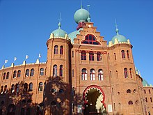
Nossa Senhora de Fátima (Lisbon)
| Nossa Senhora de Fátima | ||||||
|---|---|---|---|---|---|---|
|
||||||
| Basic data | ||||||
| Region : | Lisboa | |||||
| Sub-region : | Lisbon metropolitan area | |||||
| District : | Lisbon | |||||
| Concelho : | Lisboa | |||||
| Coordinates : | 38 ° 44 ′ N , 9 ° 9 ′ W | |||||
| Residents: | 15,312 (as of June 30, 2011) | |||||
| Surface: | 1.91 km² (as of January 1, 2010) | |||||
| Population density : | 8017 inhabitants per km² | |||||
| politics | ||||||
| Address of the municipal administration: | Junta de Freguesia de Nossa Senhora de Fátima |
|||||
| Website: | www.jf-nsfatima.pt | |||||
Nossa Senhora de Fátima was a Portuguese community ( freguesia ) in the 3rd Bairro of the capital Lisbon .
The community emerged on February 7, 1959 from the separation from the community of São Sebastião da Pedreira . It was named after the Igreja de Nossa Senhora de Fátima, built in 1938 . In the course of the administrative reform of 2013, it merged into the new Freguesia Avenidas Novas .
Buildings
- Residential house in Avenida da República, nº 23
- Igreja de Nossa Senhora de Fátima
- Museu Calouste Gulbenkian
- Praça de Touros do Campo Pequeno
- Palácio Galveias
- Tunnel do Rego
Individual evidence
- ↑ www.ine.pt - indicator resident population by place of residence and sex; Decennial in the database of the Instituto Nacional de Estatística
- ↑ Overview of code assignments from Freguesias on epp.eurostat.ec.europa.eu
Web links
- Map of the Freguesia Nossa Senhora de Fátima at the Instituto Geográfico do Exército


