Nottingham Island
| Nottingham Island | ||
|---|---|---|
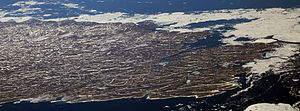
| Aerial view of Nottingham Islands | ||
| Waters | Hudson Street | |
| Archipelago | Canadian Arctic Archipelago | |
| Geographical location | 63 ° 20 ′ N , 77 ° 55 ′ W | |
|
|
||
| length | 49 km | |
| width | 35 km | |
| surface | 1 372 km² | |
| Highest elevation | 412 m | |
| Residents | uninhabited | |
Nottingham Island ( Inuktitut : Tujjaat ) is an arctic island in Nunavut , Canada. It is located at the transition from Hudson Bay to Hudson Strait .
Their land area is 1372 km². The highest point on the island reaches a height of 412 m. Nottingham Island is 49 km long and 35 km wide.
The island was discovered and named after the English city of Nottingham in 1610 by the English navigator Henry Hudson . During the Canadian Arctic expedition from 1884 to 1886, which was under the direction of Andrew Robertson Gordon (1851-1893), there was a weather station in Port de Boucherville in the southeast of the island, which was also manned in winter and whose staff particularly observed the ice conditions in the Hudson Strait should. An airfield followed in 1927. In 1970 the last Inuit left the island and settled in the larger settlements of Baffin Island , especially Cape Dorset .
Nottingham Island is known for its walrus colonies. Fraser Island, off the north-western tip of Nottingham Island, is designated by BirdLife International as an Important Bird Area (NU024).
Web links
- Nottingham Island ( Memento of December 23, 2010 in the Internet Archive ) in the island encyclopedia www.oceandots.com (English)
Individual evidence
- ↑ The Atlas of Canada - Sea Islands ( Memento from October 6, 2012 in the Internet Archive ) (English)
- ^ UN System-Wide Earth Watch Web Site - Nottingham
- ↑ Fraser Island, Hudson Strait, Nunavut on IBA Canada (English)

