Nugush
|
Nugush River Нугуш, Нөгөш |
||
|
|
||
| Data | ||
| Water code | RU : 10010200312111100017781 | |
| location | Bashkortostan ( Russia ) | |
| River system | Volga | |
| Drain over | Belaya → Kama → Volga → Caspian Sea | |
| source | in the southern Urals 53 ° 41 ′ 22 ″ N , 57 ° 26 ′ 26 ″ E |
|
| muzzle | north of Meleus in the Belaja coordinates: 53 ° 4 ′ 32 " N , 55 ° 59 ′ 43" E 53 ° 4 ′ 32 " N , 55 ° 59 ′ 43" E
|
|
| length | 235 km | |
| Catchment area | 3820 km² | |
| Drainage location: 194 km above the mouth |
MQ |
4 m³ / s |
| Reservoirs flowed through | Nugushskoye reservoir | |
|
Nugushskoye reservoir |
||
|
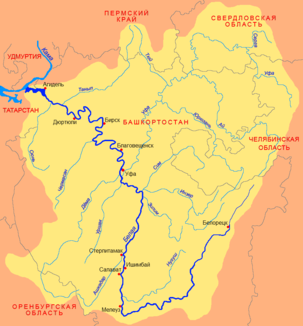
Location of the Nugusch (Нугуш) in the catchment area of the Belaya |
||
The Nugush ( Russian Нугуш ; Bashkir Нөгөш ) is a 235 km long right tributary of the Belaya in the autonomous republic of Bashkortostan in the European part of Russia .
It rises in the southern Urals and flows first in a southerly direction, later in a west-southwest direction north of the upper reaches of the Belaja and finally flows into this north of the city of Meleus . The Nugusch is ice-covered between the beginning of November and the end of April. The Nugusch drains an area of 3820 km². In 1967 the 25 km² large Nuguschskoje reservoir (capacity 400 million m³) was built on the lower reaches . The Nugush flows through the Bashkir National Park .
Individual evidence
- ↑ a b c Article Nugusch in the Great Soviet Encyclopedia (BSE) , 3rd edition 1969–1978 (Russian)
- ↑ a b Nugusch in the State Water Directory of the Russian Federation (Russian)

