O'Brien's Tower
| O'Brien's Tower | ||
|---|---|---|
|
O'Brien's Tower |
||
| Alternative name (s): | Túr Uí Bhriain | |
| Creation time : | 1835 | |
| Castle type : | Observation tower | |
| Conservation status: | well preserved | |
| Standing position : | Irish nobility | |
| Construction: | Ashlar | |
| Place: | Doolin , Liscannor | |
| Geographical location | 52 ° 58 '22.9 " N , 9 ° 25' 49.9" W | |
| Height: | 89 m ASLTemplate: height / unknown reference | |
|
|
||
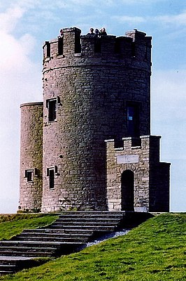
O'Brien's Tower ( Irish Túr Uí Bhriain ) is a tower at the highest point of the Cliffs of Moher near the villages of Doolin and Liscannor in County Clare, Ireland .
history
The tower was built by the local landowner and MP Sir Cornelius O'Brien in 1835 as an observation tower for the Victorian tourists on the cliffs who visited them at the time; "Strangers who visit the great scenery of this area". At first the tower is said to have served as a tea house; it was furnished with a large, round table and cast-iron seats.
Another version of the story tells of O'Brien having the tower built to impress women he adored. On a clear day, you can see from there to Loop Head on the southern tip of County Clare and even beyond to the mountains of County Kerry . To the north the view then goes to the Twelve Bens in Connemara (also called Twelve Pins ), beyond Galway Bay , to the west typically to the Aran Islands .
Individual evidence
- ^ D. Roche: The Clare Guide - Official Irish Tourist Board Guide . Bord Failte. P. 29.
swell
- Portrait of Ireland: Landscapes, Treasures, Traditions . Dorling Kindersley Travel Guides. August 1, 2000. ISBN 0-7894-6361-X .


