Oban (New Zealand)
| Oban | ||
| Geographical location | ||
|
|
||
| Coordinates | 46 ° 54 ′ S , 168 ° 8 ′ E | |
| Region ISO | NZ-STL | |
| Country |
|
|
| region | Southland | |
| District | Southland District | |
| Residents | 378 (2013) | |
| height | 10 m | |
| Post Code | 9818 | |
| Telephone code | +64 (0) 3 | |
| Photography of the place | ||
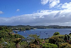
 Hafenstrasse in Oban , 1977 |
||
Oban is the only inhabited place on New Zealand's Stewart Island , New Zealand's southernmost inhabited island. As to the administrative division, Stewart Island belongs to Southland .
Origin of name
The place was probably named after Oban in Scotland by one of the Scottish settlers .
geography
Oban is located on the east side of the island in Half Moon Bay , a bay that is sometimes used as a synonym for the place name. The place stretches north to Horseshoe Bay and south to the coast to Paterson Inlet . It is around 34 km to the north-east of Oban to the mainland of the South Island .
population
For the 2013 census, Oban had 378 residents.
economy
Oban experienced a slight economic upswing and received several million in subsidies from the government, since tourism increased significantly after the opening of the Rakiura National Park .
Infrastructure
Road traffic
Road access is only available within Oban town , not to any other part of Stewart Island .
Air traffic
Oban has a 630 m long asphalt runway in a wooded area, around 1.7 km west of the town center. From this runway there are flight connections to Invercargill in the south of the South Island.
Shipping
There is a ferry connection between Oban and Bluff on the South Island. Occasionally, cruise ships stop in Oban . However, they do not anchor in the relatively narrow Half Moon Bay , but in the bay of Paterson Inlet and take the passengers with tender boats to a small pier in Golden Bay . From there it is about 700 m over a ridge to Oban .
Web links
- Stewart Island Maps . Stewart Island Promotion Association,accessed September 7, 2017.
Individual evidence
- ↑ a b 2013 Census QuickStats about a place: Stewart Island . Statistics New Zealand , accessed on September 7, 2017 (English, StatsMap: Meshblock analysis from the interactive map).
- ↑ Oban . .NZ.com , accessed September 7, 2017 .
- ↑ Topo250 maps . Land Information New Zealand , accessed September 7, 2017 .
- ↑ Stewart Island gets $ 5.6m cash boost . In: New Zealand Herald . NZME. Publishing , July 12, 2005, accessed June 12, 2018 .

