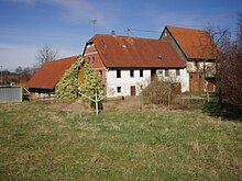
Upper mill (Berwangen)
The Obere Mühle is a former mill property in Berwangen , a district of Kirchardt in the Heilbronn district in northern Baden-Württemberg .
location
The Obere Mühle property is located in the east of Berwangen at the confluence of the Fürfelder Weg and Hausener Straße. Its base area is almost 3,000 m 2 , most of which is covered by a flat meadow that was last used as a horse pasture. The driveway to the barn and the access to its basement run from the south across the property, the barn floor is accessible from the higher Fürfelder Weg. After the Fürfelder Weg was expanded, the east corner of the barn does not protrude into this street itself, according to the new survey, but into its public space. To the north, garden areas and fields adjoin the property, to the west and south there are loose residential buildings, to the east there are some other properties, some of which are still used for agriculture.
history
There was probably a mill in the east of Berwangen as early as the late Middle Ages . In 1557 an upper garbage was named there, whose miller had to pick up the grain from the needy Berwangen residents within a radius of a mile and deliver the flour on the third day. The lower mill , following the course of the brook in the southwest of the village, was Bannmühle in 1557 . Both mills were destroyed in the Thirty Years War and later rebuilt.
In 1753 Paul Kreb and his wife Maria Margarete built the Obere Mühle , the structural remains of which are preserved today. The building site was on the left in the wide floodplain of the Birkenbach, at the confluence of Fürfelder Weg and Hausener Strasse. The owner and the year of construction were named on a stone that was once on the property.
The property consisted of a two-storey barn with a grinding room, an attached barn on a limestone foundation, a two-storey extension along the Fürfelder Weg with accommodation for the mill servants on the upper floor and a pigsty in the basement as well as a shed. A mill canal from the nearby Birkenbach, which flows further down the valley as Berwanger Bach to the Elsenz , conducted the driving water to the mill wheel . Because the upper Mühlkanal had very little gradient and often silted up, the water from the Birkenbach at a weir at the Many Wells , a good half a kilometer up the valley, could be diverted into the Keitländer Graben , which meant that the Mühlkanal no longer received any water, fell dry and was removed from the mud could be cleaned.
The mill was initially just a flour mill and changed hands several times. In 1853 Caspar Vollweiler took over the property, around 1900 the Hubele family came into their possession, and in 1912 the miller Friedrich Sitzler bought the property. Sitzler expanded the mill to include a chopping machine, a fruit grinder and a threshing machine, and he also installed a generator for electrical lighting. In 1935 he also installed a diesel engine ; so he was able to keep the mill running even in times of water scarcity. Lastly, grain was crushed in the mill.
Because Friedrich Sitzler's son had stayed during the Second World War, the miller stopped running the mill when he was old and sold the mill. The property was then used for residential and changing commercial purposes. In the course of the land consolidation from 1967, the Birkenbach was straightened and partially relocated and the mill channels leading to the Berwang mills were filled. After that, the outbuilding, once inhabited by the millers, was torn down, of which only a few foundations and cellars and a small arched vault can be found on the site. In 1982 the still preserved shed was expanded into a horse stable and stocked up. The barn with a floor area of 113 m 2 was largely renovated in the 1990s, no corresponding measures were taken on the residential building with its 152 m 2 floor area. Around the year 2000, the now dilapidated house was secured, and the west wall of the building was rebuilt in 2001 and a supporting structure underpinned the roof structure. In 2011, the house was demolished, so that now only the remaining barn and some wall remnants from outbuildings point to the old property.
literature
- Berwangen, Bockschaft, Kirchardt. A second home book . Kirchardt municipality, Kirchardt 1993, DNB 94863281X .
- Heinz Tuffentsammer: The mills in the city and district of Heilbronn (= Mühlenatlas Baden-Württemberg Volume 4) , Remshalden 2005, part 4.2, p. 111, no. 6819-714.
- Susanne Eckert: Upper Mill Berwangen. Heidelberg 2008.
Web links
Coordinates: 49 ° 11 ′ 6 " N , 8 ° 59 ′ 15.1" E


