Oberneustadt

The Oberneustadt refers to the area of the first planned new development of a district outside the old town of Kassel, which is enclosed by city walls . Today it is part of the city center and the inner city .
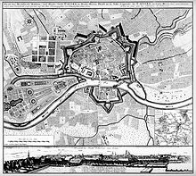
The Kassel Oberneustadt was laid out in 1689 by Landgrave Karl von Hessen-Kassel as a planned city for Protestant religious refugees, the Huguenots , who were expelled from France after the edict of Nantes was repealed in 1685. The unpaved in front of the fortress walls of the old town and separated from it by a tree-lined esplanade with a regular floor plan had as its center the Karlskirche, which was designed as a central building and completed in 1706, by Paul du Ry, who also fled Paris . Landgrave Wilhelm I issued a separate building code for Oberneustadt in 1751 .
The spatial conclusion forms the natural boundary of the southeast to the Karlsaue descending slope from which the Landgrave's Castle since razing of the fortifications along the theater was reached and the colonnades on foot. The northern end of the quarter is formed by the axis of the new Königsstraße , which ran roughly along the course of the old fortress walls from the Drusel- and Köllnischer Tor below the ridge between the Rothenberge and Zwehren that sloped from the west. Today Oberneustadt is a street that runs north of the old town and leads centrally over the Königsplatz to the southwest, which is connected to the old town by the wide Friedrichsplatz instead of the former fortifications. In the area of the further course, the Wilhelmshöher Tor at today's Brüder-Grimm-Platz forms a pentagonal deflection of the axis in the avenue towards the Weißenstein castle.
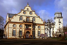
The new building of the Kassel town hall , built by Karl Roth between 1905 and 1909, added a castle-like structure to the baroque style in the area of the northwest street block between Fünffensterstraße and Wilhelmsstraße instead of the previous, small-scale development.
Today, the original structure of the well-ordered streets has been destroyed by the road construction of the inner-city ring that was implemented up until the 1960s. The blocks delimited by Friedrichstrasse have been reduced in area at this point due to the widening of Fünffensterstrasse, the line between Palais Bellevue and Friedrichsplatz along the Schöne Aussicht through Bundesstrasse 7 is also cut off from the perfection of the original district. In addition, the buildings of the judicial authorities now sanction the uniformity of the original development.
The facility in the city of Bad Karlshafen on the Weser offers a direct structural and historical comparison .
literature
- Alois Holtmeyer : The architectural and art monuments in the administrative district of Cassel. Vol. 6: District of Cassel-Stadt , Marburg 1923.
- Waltraud Wagner: Urban planning of the Huguenots using the example of Oberneustadt-Kassel and Bad Karlshafen in Hessen. 1987.
Individual evidence
- ↑ Regulations. Wornach The building on the Ober-Neustadt all here should be set up for the future on Google Books
Coordinates: 51 ° 18 ′ 42 " N , 9 ° 29 ′ 41" E


