Ocmulgee River
| Ocmulgee River | ||
|
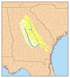
Overview map of the Ocmulgee river system (highlighted) |
||
| Data | ||
| Water code | US : 356443 | |
| location | Georgia ( USA ) | |
| River system | Altamaha River | |
| Drain over | Altamaha River → Atlantic Ocean | |
| origin | Lake Jackson Reservoir 33 ° 19 ′ 15 ″ N , 83 ° 50 ′ 30 ″ W. |
|
| muzzle | Confluence with the Oconee River to the Altamaha River Coordinates: 31 ° 57 ′ 33 " N , 82 ° 32 ′ 37" W 31 ° 57 ′ 33 " N , 82 ° 32 ′ 37" W
|
|
| length | 410 km | |
|
Ocmulgee River near Macon |
||
The Ocmulgee River [ oʊ̯kˈməlɡiː ˈɹɪvɚ ] is a tributary of the Altamaha River with a length of about 410 km, which runs in the state of Georgia in the southeastern United States . The relatively unspoilt and gently flowing river is the major drainage of the Piedmont region and the coastal region of the central Georgia area.
course
The river is created southeast of the city of Atlanta by the confluence of the Yellow , South and Alcovy Rivers , which form arms of the Lake Jackson reservoir . The Ocmulgee runs southeast of Macon , there the river in its fall line overcomes the height difference between the Piedmont Plateau and the coastal plain and connects with the Oconee River coming from the northwest near Lumber City to the Altamaha River.
Below Lake Jackson, the river flows without any containment or straightening, making it different from most rivers in the region. The low flow speed of around 24 centimeters per kilometer makes the river calm and wide over large parts of its course. This makes the river very popular with canoeists . The Ocmulgee absorbs treated water from 13 sewage works along the river and is a well-known area for fishing for catfish and perch .
history
The river banks were populated by the Mississippi culture between the 10th and 12th centuries . Several remains of prehistoric Indian settlements have been found in the region around Macon, now part of the Ocmulgee National Monument . In 1540, the Spanish explorer Hernando de Soto traveled through the region and baptized some converted Native Americans in the Ocmulgee River. In the 18th century, the Hitchiti , later members of the Creek nation, settled not far from today's Macon in Ocmulgee Old Fields . The name of the river probably comes from the Hitchiti language and means “bubbling water” ( oki mulgis ). In 1806 the United States acquired the area from the Creek tribes of the Oconee and Ocmulgee through the First Treaty of Washington . In the same year, the United States Army built Fort Benjamin Hawkins above Ocmulgee Fields. The last meeting of the Creek at Old Field was in 1819.
The first steamboat sailed the river in 1829 and as a result the Ocmulgee became an important waterway for the cotton industry in the Macon region and promoted its development. In 1842 the river was connected to the railway line to Savannah . The river froze completely from bank to bank in 1886, a heavy flood hit the region after heavy rains in 1994 and caused great damage in and around Macon.

