Oddsskarð
| Oddsskarð | |||
|---|---|---|---|
|
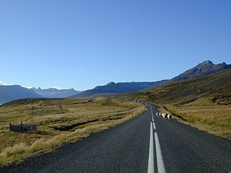
Sheep on the driveway to the tunnel at Oddsskarð, on the Eskifjörður side |
|||
| Compass direction | southwest | Northeast | |
| Pass height | 705 m above sea level NN | ||
| region | Iceland | ||
| Valley locations | Eskifjörður | Neskaupstaður | |
| expansion | Pass road | ||
| Map (Iceland) | |||
|
|
|||
| Coordinates | 65 ° 4 '36 " N , 13 ° 53' 7" W | ||
The Oddsskarð is a pass in the east fjords of Iceland . The Norðfjarðarvegur passed over him ![]() .
.
High pass road
This road from 1949 is one of the highest in Iceland at 705 m, higher roads can only be found in the highlands . It connected the places Neskaupstaður and Eskifjörður by the 626 m long, single-lane Oddsskarðsgöng . It is located at 632 m above sea level. M.
Because of this location v. a. If there are repeated problems with the transport links between Eskifjörður and Neskaupstaðir in winter, a new tunnel was planned elsewhere, which leads through the mountain much more flatly.
The Norðfjarðargöng was opened on November 11, 2017 . This tunnel is 7542 m long and the road connection now runs through it.
Ski area of the same name
On the south side of the tunnel at Oddskarð there is a ski area, which is also called the Alps of the East Fjords . The lifts start at a height of 513 m and go up to 840 m, from where you can see far over the Reyðarfjörður fjord in appropriate weather conditions . The ski area has been with lifts since 1988, with floodlights since 1994 and has been recognized by the International Ski Association as suitable for international ski competitions. There was the ski operation z. B. possible for almost 3 months in winter 2007/08.
See also
Web links
Individual evidence
- ↑ Austast á Austurlandi. Retrieved July 23, 2018 (Icelandic).
- ↑ Íslandshandbókin. 2. bindi. 1989, p. 634
- ↑ Vegahandbókin. Edited by Landmælingar Íslands. 2006, p. 578
- ↑ mbl.is accessed on January 17, 2011
- ↑ vegagerdin.is accessed on January 17, 2011
- ↑ cf. also Icelandic State Planning Authority Skipulagsstofnun (PDF; Icelandic); Retrieved January 17, 2011
- ↑ cf. Vegahandbókin. Edited by Landmælingar Íslands. 2006, p. 412
- ↑ cf. fjardabyggd.is ( Memento of the original from February 9, 2011 in the Internet Archive ) Info: The archive link was automatically inserted and not yet checked. Please check the original and archive link according to the instructions and then remove this notice. Retrieved January 17, 2011


