Ommanney Bay
| Ommanney Bay | ||
|---|---|---|
|
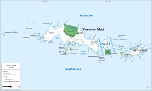
Map of Coronation Island (center) with Ommanney Bay |
||
| Waters | Scotia Lake | |
| Land mass | Coronation Island , South Orkney Islands | |
| Geographical location | 60 ° 33 ′ 0 ″ S , 45 ° 31 ′ 59 ″ W | |
|
|
||
| width | 3 km | |
| Islands | Islote Brusa , Yordanov Island | |
The Ommanney Bay is a 3-km wide bay on the north coast of Coronation Iceland in the archipelago of the South Orkney Islands . It is located between Prong Point and Foul Point . The bay belonged to Antarctic Specially Protected Area No. 114 , but its protection status was lifted on August 5, 2014.
The British sealer captain George Powell and his American counterpart Nathaniel Palmer discovered and mapped them together in December 1821. Scientists from the British Discovery Investigations mapped them again in 1933 and named them after the zoologist Francis Downes Ommanney (1903-1980), who from 1929 to 1939 was a member of the research series committee.
Web links
- Ommanney Bay in the Geographic Names Information System of the United States Geological Survey (English)
- Ommanney Bay on geographic.org (English)

