Pfanzeltplatz
| Pfanzeltplatz | |
|---|---|
| Place in Munich | |
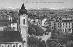
 View over the parish church of St. Michael onto Pfanzeltplatz in Perlach, postcard, around 1910 |
|
| Basic data | |
| place | Munich |
| District | Perlach |
| Newly designed | 1989/90 |
| Confluent streets | Hofmarkstrasse, Putzbrunner Strasse, Sebastian-Bauer-Strasse, Josef-Beiser-Strasse, Ottobrunner Strasse |
| Buildings | St. Michael |
| use | |
| User groups | Pedestrian traffic , bicycle traffic , individual traffic , public transport |
| Space design | Maypole , Perlach war memorial, history fountain |
The Pfanzeltplatz is the center of the former village Perlach , which is now part of the Munich Municipality Ramersdorf-Perlach is.
The entire square is protected as an ensemble and some buildings are listed (see architectural monuments in Perlach ).
The Pfanzeltplatz is located in the Unterdorf and is named after Martin Pfanzelt (* April 25, 1825 - August 24, 1912 ), who was Perlach pastor from 1869 to 1912 (also royal spiritual councilor, dean, district school inspector and honorary citizen of the Perlach community) .
The Pfanzeltplatz is traversed by the Hachinger Bach , alongside the Catholic parish church of St. Michael , the maypole , the war memorial, the elementary school, the historical fountain , the Zur Post restaurant and the Sedlmeir butcher's shop . Since the redesign in 1989/90 (landscape architect Gottfried Hansjakob ), all traffic has been relocated to the left side of the stream, the right side is reserved for pedestrians.
In the direction of the city center, Pfanzeltplatz merges into Ottobrunner Straße, in the direction out of town it becomes Putzbrunner Straße or Sebastian-Bauer-Straße. Pfanzeltplatz can be reached publicly with bus lines 55 and 139 of the MVV .
Every Saturday there is an organic market on the square .
Web link
Coordinates: 48 ° 6 ′ 0 ″ N , 11 ° 37 ′ 50 ″ E
