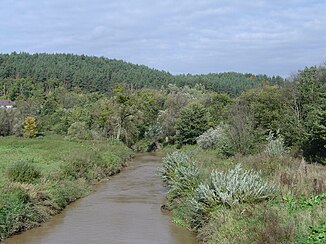
Osa (river)
|
Osa Ossa |
||
|
The Osa at Grudziądz |
||
| Data | ||
| location | Poland | |
| River system | Vistula | |
| Drain over | Vistula → Baltic Sea | |
| origin | Lake Perkun, west of Jeziorak 53 ° 42 ′ 29 ″ N , 19 ° 32 ′ 43 ″ E |
|
| muzzle | near Zakurzewo, north of Grudziądz , in the Vistula Coordinates: 53 ° 33 ′ 20 ″ N , 18 ° 45 ′ 55 ″ E, 53 ° 33 ′ 20 ″ N , 18 ° 45 ′ 55 ″ E
|
|
| length | 96.2 km | |
| Catchment area | 1600 km² | |
| Right tributaries | Gardęga | |
The Osa ( German Ossa ) is a river in the Polish provinces Masuria and Kujawy .
It has a length of 96.2 kilometers and a catchment area of 1,600 km². It has its origins in Perkun Lake and empties near Zakurzewo ( Sackrau ) north of Grudziadz (Graudenz) , in the Vistula .
In the area where it flows into the Vistula is the Graudenz fortress, which is framed by the river from the north and east.
In 1994, the river was placed under nature protection over a length of 14 kilometers , creating the Ossa Valley nature reserve .
The river was mentioned as the border of the Kulmerland as early as 1222 . From 1918 to 1945 it formed part of the border between Poland and East Prussia .
literature
- August Eduard Preuss : Prussian country and folklore or description of Prussia . Gebrüder Bornträger, Königsberg 1835, pp. 29–30 and p. 46.
