Osingsee
| Osingsee | ||
|---|---|---|

|
||
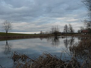
| The Osingsee, with the Osinghaus information hut on the eastern bank in the background | ||
| Geographical location | In the postage stamp Osing | |
| Drain | Ehebach → Aisch → Regnitz → Main → Rhine → North Sea | |
| Places on the shore | (Osinghaus) | |
| Location close to the shore |
Bad Windsheim (Humprechtsau, Rüdisbronn) Sugenheim Market (Krautostheim) Nordheim Market (Herbolzheim) |
|
| Data | ||
| Coordinates | 49 ° 33 '57.1 " N , 10 ° 23' 24.2" E | |
|
|
||
| Altitude above sea level | 370.5 m above sea level NN | |
| surface | 0.72 ha | |
| length | 160 m | |
| width | 65 m | |
| scope | 400 m | |

|
||
The Osingsee (from mhd. Asanc , entpr. Absegnen, abgesegnetes) is a small lake in the franking of Osing .
The lake has an area of around 0.72 hectares, is 160 m long from east to west and up to 65 m wide in the western part. It lies at an altitude of about 370 m above sea level. NHN and drains to the northwest into the Ehebach near Krautostheim (municipality of Markt Sugenheim ), a tributary of the Aisch . The lake is used as a carp pond .
At the eastern end is the Osinghaus, where the Osingfest takes place every year in August.
