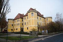
Sugenheim
| coat of arms | Germany map | |
|---|---|---|

|
Coordinates: 49 ° 36 ' N , 10 ° 26' E |
|
| Basic data | ||
| State : | Bavaria | |
| Administrative region : | Middle Franconia | |
| County : | Neustadt ad Aisch-Bad Windsheim | |
| Management Community : | Scheinfeld | |
| Height : | 312 m above sea level NHN | |
| Area : | 63.38 km 2 | |
| Residents: | 2324 (Dec. 31, 2019) | |
| Population density : | 37 inhabitants per km 2 | |
| Postcodes : | 91484, 91438 | |
| Primaries : | 09165, 09164 | |
| License plate : | NEA, SEF, UFF | |
| Community key : | 09 5 75 165 | |
| LOCODE : | DE SG9 | |
| Market structure: | 14 parts of the community | |
Market administration address : |
Kirchstrasse 17 91484 Sugenheim |
|
| Website : | ||
| Mayor : | Reinhold Klein (Free Voters Upper Marriage Reason) | |
| Location of the Sugenheim market in Neustadt adAisch-Bad Windsheim | ||
Sugenheim is a market in the district of Neustadt an der Aisch-Bad Windsheim in Middle Franconia and a member of the Scheinfeld administrative association .
geography
Geographical location
The community is located between central Nuremberg and Würzburg in the southern Steigerwald in Ehegrund, a field landscape created by Ehebach . The larger districts are all on the banks of the Ehebach or on the small marriage that flows into it .
Community structure
The municipality has 14 officially named municipal parts (the type of settlement is indicated in brackets ):
|
|
Neighboring communities
Neighboring communities are (starting from the north clockwise): Markt Bibart , Scheinfeld , Langenfeld , Neustadt an der Aisch , Ipsheim , Bad Windsheim , Markt Nordheim , Weigenheim , Ippesheim , Willanzheim and Iphofen .
history
Sugenheim was founded in the Franconian feudal area in the 9th century. In 1298 the place was first mentioned as "Subenheim", since 1366 the current form "Sugenheim" is attested. The defining word of the place name is the personal name Subo, which can be seen as the founder of the place.
The barons of Seckendorff gradually acquired a closed rulership complex from the feudal lords Castell and Hohenlohe and built a castle. From 1528 the Reformation took place in the region . Florian von Seckendorff had already employed evangelical clergy in Sugenheim in 1524 (in 1533 he made the commitment to the Augsburg confession and thus officially carried out the Reformation). (For Krautostheim, where the Hussite traveling preacher Friedrich Müller had already met open ears in 1446, a Protestant pastor is only recorded in 1570 or - with Michael Veit Treuer in 1597.). The palace complex, newly built around 1600, encompassing three wings with the small courtyard adorned by a gallery and four massive corner towers still shows something of the character of the extensive imperial aristocracy that belonged to the Franconian knight circle . After the end of the Thirty Years War , numerous Protestant religious expellees from Austria settled there and contributed significantly to the reconstruction.
In 1596 seven women and one man (from Sugenheim, Ezelheim and Deutenheim) were arrested, tortured and executed for witchcraft in Sugenheim . Of four other women arrested for the same reason, one died in prison and three were expelled from the country in 1597.
At the end of the 18th century there were 116 properties in Sugenheim. The high court and the village and community rule exercised the rule of Sugenheim . The landlords were the Lordship of Sugenheim (2 castles, official building, dairy, gardening, church, rectory, Jewish school, sheep farm, 6 farms, 37 estates, 11 estates, 38 houses, 2 taverns, 2 mills, forge, shepherd's house; 1 heap with kiln, 2 fire houses, 2 gatehouses) and the parish Sugenheim (5 estates).
In 1796, Sugenheim was captured by Prussian troops and incorporated into the Kingdom of Prussia . In 1810 Sugenheim came to the new Kingdom of Bavaria . As part of the municipal edict , the tax district Sugenheim was formed in 1811 , to which Deutenheim , Dutzenthal , Ezelheim , Hürfeld and Rüdern belonged. In 1813 the rural community Sugenheim was formed, which was congruent with the tax district. With the second community edict (1818), the rural community was split into
- Rural community Deutenheim with Dutzenthal;
- Rural community Ezelheim;
- Rural community Sugenheim with Hürfeld and Rüdern.
The administration and jurisdiction of the rural community Sugenheim was subordinate to the District Court of Windsheim and the financial administration to the Ipsheim Rent Office . The voluntary jurisdiction and local police were held by the Sugenheim Patrimonial Court until 1848 , and the Ullstadt Patrimonial Court over three properties. On July 3, 1838, the community was handed over to the district court of Markt Bibart and the Iphofen Rent Office . From 1862 Sugenheim was administered by the Scheinfeld district office (renamed the Scheinfeld district in 1938 ) and from 1856 by the Markt Bibart rent office (1920–1929: Markt Bibart tax office , from 1929: Neustadt an der Aisch tax office ). The jurisdiction remained with the district court of Markt Bibart until 1879, from 1880 the district court of Scheinfeld . In 1961 the municipality had an area of 13,240 km².
Incorporations
On January 1, 1972, the previously independent communities of Deutenheim, Ezelheim, Ingolstadt, Krassolzheim, Krautostheim and Neundorf were incorporated with their respective districts. Ullstadt was added on May 1, 1978.
Population development
| year | 1818 | 1840 | 1852 | 1861 | 1867 | 1871 | 1875 | 1880 | 1885 | 1890 | 1895 | 1900 | 1905 | 1910 | 1919 | 1925 | 1933 | 1939 | 1946 | 1950 | 1961 | 1970 | 1987 | 2007 | 2012 | 2016 |
|---|---|---|---|---|---|---|---|---|---|---|---|---|---|---|---|---|---|---|---|---|---|---|---|---|---|---|
| Sugenheim community | ||||||||||||||||||||||||||
| Residents | 754 | 785 | 764 | 808 | 814 | 832 | 795 | 814 | 829 | 807 | 804 | 772 | 726 | 690 | 665 | 638 | 642 | 596 | 1114 | 1044 | 768 | 939 | 2333 | 2325 | 2312 | 2251 |
| Houses | 141 | 141 | 147 | 152 | 148 | 141 | 145 | 167 | 665 | 753 | ||||||||||||||||
| source | ||||||||||||||||||||||||||
| Sugenheim part of the municipality | ||||||||||||||||||||||||||
| Residents | 668 | 707 | 720 | 724 | 737 | 698 | 569 | 914 | 691 | 874 | 942 | |||||||||||||||
| Houses | 122 | 124 | 135 | 133 | 129 | 129 | 152 | 262 | ||||||||||||||||||
| source | ||||||||||||||||||||||||||
politics
Market council
The 2014 local elections resulted in the following distribution of seats (in brackets compared to the 2008 election):
- CSU 2 seats (± 0)
- SPD 3 seats (+1)
- Free community of voters Ullstadt 2 seats (± 0)
- Free voters Upper reason for marriage 5 seats (± 0)
- Independent voters 2 seats (-1)
badges and flags
The community of Sugenheim has had a coat of arms since 1958.
|
Blazon : "Under the red shield head in silver, a loop-shaped bent red linden branch with four leaves on the outside."
Red and white municipal flag |
|
| Justification for the coat of arms: The looped linden branch is taken from the coat of arms of the Lords of Seckendorff and reminds of their long reign. The red head symbolizes the high judiciary. |
Town twinning
Culture and sights
Museums
- Toy museum in the old castle
- Local history museum in the former sheep barn: It shows agricultural implements, household items, a post office, a cobbler's shop, tools from the old days and much more. The local homeland and horticultural association looks after the collection. The opening always takes place on the day of the Open Monument on the second Sunday in September and on request.
Buildings
- Protestant Margrave Church of St. Erhard
- Old and New Castle
- Sugenheim primary school for marriage
- House of clubs
Architectural monuments
Parks
- English style palace garden
Sports
- RSV Sugenheim 1947 e. V.
- The RSV Sugenheim offers the sports football (promotion up to the 1st district class ), gymnastics, karate and tennis.
Infrastructure and economy
traffic
The state road 2256 leading to Interpret home or after Ullstadt . The state road 2253 cites Hürfeld and Fuchsau over after Markt Bibart to State Road 8 . The district road NEA 31 leads to Ezelheim .
Established businesses
- Fa. Staedtler
- Bus company HÖHN
- Kachler-Hoferer butcher's shop
Personalities
Sons and Daughters of the Market
- Georg Friedrich Rebmann (1768–1824), lawyer and reformer
- Karl-Ludwig Kelber (* 1932), journalist and ADFC functionary
Other personalities associated with the market
- John Albert Marx (* about 1719; † 1773), ancestor of line Zastrow Marcks of the noble family von Zastrow
- Fritz Schöller (born July 29, 1909 in Neustadt an der Aisch; † May 3, 1973 in Löffingen), teacher and politician (NSDAP), in Ingolstadt from October 1, 1957 teacher in Ingolstadt (then the Scheinfeld district) and from February 1 1967 to 1971 Rector of the Ingolstadt-Oberer Ehegrund Association School
- Jan K. Kube (* 1949), militaria dealer and auctioneer
literature
- Johann Kaspar Bundschuh : Sugenheim . In: Geographical Statistical-Topographical Lexicon of Franconia . tape 5 : S-U . Verlag der Stettinische Buchhandlung, Ulm 1802, DNB 790364328 , OCLC 833753112 , Sp. 478-479 ( digitized version ).
- Hanns Hubert Hofmann : Neustadt-Windsheim (= Historical Atlas of Bavaria, part of Franconia . I, 2). Commission for Bavarian State History, Munich 1953, DNB 452071216 , p. 133 ( digitized version ). Ibid. S. 220 ( digitized version ).
- Gerhard Hojer: District of Scheinfeld (= Bavarian art monuments . Volume 35 ). Deutscher Kunstverlag, Munich 1976, DNB 760102457 , p. 312-333 .
- Gerhard Rechter: Sugenheim , in: Graf Jesko zu Dohna and Robert Schuh (eds.): In the footsteps of the princes zu Schwarzenberg , Scheinfeld 2006, pp. 58–61.
- Wolf-Armin von Reitzenstein : Lexicon of Franconian place names. Origin and meaning . Upper Franconia, Middle Franconia, Lower Franconia. CH Beck, Munich 2009, ISBN 978-3-406-59131-0 , p. 216 .
- Peter Schneider : The Steigerwald as a whole . Stürtz, Würzburg 1958, DNB 454428790 , p. 241-242 .
- Pleikard Joseph Stumpf : Suggenheim . In: Bavaria: a geographical-statistical-historical handbook of the kingdom; for the Bavarian people . Second part. Munich 1853, p. 697 ( digitized version ).
Web links
- Sugenheim: Official statistics of the LfStat
- Sugenheim in the Topographia Franconiae of the University of Würzburg , accessed on September 19, 2019.
- Sugenheim in the historical directory of the association for computer genealogy
Individual evidence
- ↑ "Data 2" sheet, Statistical Report A1200C 202041 Population of the municipalities, districts and administrative districts 1st quarter 2020 (population based on the 2011 census) ( help ).
- ^ Community Sugenheim in the local database of the Bayerische Landesbibliothek Online . Bayerische Staatsbibliothek, accessed on September 19, 2019.
- ↑ See on Ingolstadt: Hermann Rölz, Ingolstadt, in: Graf Jesko zu Dohna and Robert Schuh (eds.): On the trail of the princes zu Schwarzenberg, Scheinfeld 2006, p. 66
- ↑ See on Krassolzeim: Friedhelm Gleiß, Krassolzheim, in: Graf Jesko zu Dohna and Robert Schuh (eds.): On the traces of the princes zu Schwarzenberg, Scheinfeld 2006, pp. 68–69
- ^ Hermann Rölz: Krautostheim. In: Graf Jesko zu Dohna, Robert Schuh (Ed.): In the footsteps of the princes zu Schwarzenberg. Scheinfeld 2006, p. 64 f.
- ↑ W.-A. v. Reitzenstein, p. 216.
- ↑ Max Döllner (1950), p. 191.
- ^ Max Döllner : History of the development of the city of Neustadt an der Aisch up to 1933. Ph. C. W. Schmidt, Neustadt a. d. Aisch 1950, OCLC 42823280 ; New edition to mark the 150th anniversary of the Ph. C. W. Schmidt publishing house, Neustadt an der Aisch 1828–1978. Ibid 1978, ISBN 3-87707-013-2 , pp. 190 and 192.
- ↑ Eberhard Krauss: Exulanten im Evang.-Luth. Deanery Neustadt an der Aisch. Nuremberg 2012 (sources and research on Franconian family history, 27), passim. ISBN 978-3-929865-32-5
- ↑ Traudl Kleefeld: Against forgetting: witch hunt in Franconia - places of remembrance. JH Röll, Dettelbach 2016, p. 11 ff.
- ↑ Max Döllner (1950), p. 213.
- ↑ HH Hofmann, p. 133.
- ^ Address and statistical manual for the Rezatkreis in the Kingdom of Baiern . Buchdruckerei Chancellery, Ansbach 1820, p. 73 ( digitized version ). HH Hofmann p. 227.
- ↑ HH Hofmann, p. 220.
- ↑ a b c Bavarian State Statistical Office (ed.): Official city directory for Bavaria, territorial status on October 1, 1964 with statistical information from the 1961 census . Issue 260 of the articles on Bavaria's statistics. Munich 1964, DNB 453660959 , Section II, Sp. 822 ( digitized version ).
- ^ Wilhelm Volkert (ed.): Handbook of Bavarian offices, communities and courts 1799–1980 . CH Beck, Munich 1983, ISBN 3-406-09669-7 , p. 565 .
- ^ Federal Statistical Office (ed.): Historical municipality directory for the Federal Republic of Germany. Name, border and key number changes in municipalities, counties and administrative districts from May 27, 1970 to December 31, 1982 . W. Kohlhammer, Stuttgart / Mainz 1983, ISBN 3-17-003263-1 , p. 723 .
- ↑ a b Only inhabited houses are given. In 1818 these were designated as fireplaces , in 1840 as houses , and from 1871 to 2016 as residential buildings.
- ↑ a b Alphabetical index of all the localities contained in the Rezatkreise according to its constitution by the newest organization: with indication of a. the tax districts, b. Judicial Districts, c. Rent offices in which they are located, then several other statistical notes . Ansbach 1818, p. 90 ( digitized version ). For the community of Sugenheim plus the residents and buildings of Hürfeld (p. 44) and Rüdern (p. 79).
- ^ A b Eduard Vetter (Ed.): Statistical handbook and address book of Middle Franconia in the Kingdom of Bavaria . Self-published, Ansbach 1846, p. 62 ( digitized version ).
- ↑ a b c d e f g h i j k l Bavarian State Statistical Office (Hrsg.): Historical municipality directory: The population of the municipalities of Bavaria from 1840 to 1952 (= contributions to Statistics Bavaria . Issue 192). Munich 1954, DNB 451478568 , p. 183 , urn : nbn: de: bvb: 12-bsb00066439-3 ( digitized version ).
- ↑ a b Joseph Heyberger, Chr. Schmitt, v. Wachter: Topographical-statistical manual of the Kingdom of Bavaria with an alphabetical local dictionary . In: K. Bayer. Statistical Bureau (Ed.): Bavaria. Regional and folklore of the Kingdom of Bavaria . tape 5 . Literary and artistic establishment of the JG Cotta'schen Buchhandlung, Munich 1867, Sp. 1084 , urn : nbn: de: bvb: 12-bsb10374496-4 ( digitized version ).
- ↑ a b Kgl. Statistical Bureau (ed.): Complete list of localities of the Kingdom of Bavaria. According to districts, administrative districts, court districts and municipalities, including parish, school and post office affiliation ... with an alphabetical general register containing the population according to the results of the census of December 1, 1875 . Adolf Ackermann, Munich 1877, 2nd section (population figures from 1871, cattle figures from 1873), Sp. 1250 , urn : nbn: de: bvb: 12-bsb00052489-4 ( digitized ).
- ↑ a b K. Bayer. Statistical Bureau (Ed.): Localities directory of the Kingdom of Bavaria. According to government districts, administrative districts, ... then with an alphabetical register of locations, including the property and the responsible administrative district for each location. LIV. Issue of the contributions to the statistics of the Kingdom of Bavaria. Munich 1888, Section III, Sp. 1184 ( digitized version ).
- ↑ a b K. Bayer. Statistical Bureau (Ed.): Directory of localities of the Kingdom of Bavaria, with alphabetical register of places . LXV. Issue of the contributions to the statistics of the Kingdom of Bavaria. Munich 1904, Section II, Sp. 1256 ( digitized version ).
- ↑ a b Bavarian State Statistical Office (ed.): Localities directory for the Free State of Bavaria according to the census of June 16, 1925 and the territorial status of January 1, 1928 . Issue 109 of the articles on Bavaria's statistics. Munich 1928, Section II, Sp. 1294 ( digitized version ).
- ↑ a b Bavarian State Statistical Office (ed.): Official place directory for Bavaria - edited on the basis of the census of September 13, 1950 . Issue 169 of the articles on Bavaria's statistics. Munich 1952, DNB 453660975 , Section II, Sp. 1121 ( digitized version ).
- ↑ a b Bavarian State Statistical Office (Hrsg.): Official local directory for Bavaria . Issue 335 of the articles on Bavaria's statistics. Munich 1973, DNB 740801384 , p. 176 ( digitized version ).
- ↑ a b Bavarian State Office for Statistics and Data Processing (Ed.): Official local directory for Bavaria, territorial status: May 25, 1987 . Issue 450 of the articles on Bavaria's statistics. Munich November 1991, DNB 94240937X , p. 342 ( digitized version ).
- ↑ a b c Sugenheim: Official statistics of the LfStat
- ^ Entry on the coat of arms of Sugenheim in the database of the House of Bavarian History
- ↑ Sugenheim. In: Kommunalflaggen.eu. Retrieved May 24, 2020 .
- ^ Wolfgang Mück: Nazi stronghold in Middle Franconia: The völkisch awakening in Neustadt an der Aisch 1922–1933. Verlag Philipp Schmidt, 2016 (= Streiflichter from home history. Special volume 4); ISBN 978-3-87707-990-4 , pp. 233–239 ( Schöller, Fritz ("Schwarzer"). ), Here: pp. 238 f.


