Osterau (Bramau)
| Osterau | ||
|
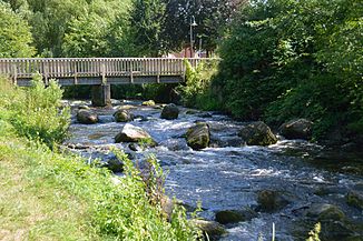
The Osterau in Bad Bramstedt a few meters before the confluence with the Hudau to the Bramau |
||
| Data | ||
| Water code | DE : 597665 + 597667 | |
| location | Schleswig-Holstein , Germany | |
| River system | Elbe | |
| Drain over | Bramau → Stör → Elbe → North Sea | |
| origin | Confluence of the Radesford Au and Rothenmühlenau in Heidmühlen 53 ° 58 ′ 26 ″ N , 10 ° 5 ′ 9 ″ E |
|
| confluence | in Bad Bramstedt with the Hudau to Bramau coordinates: 53 ° 55 ′ 8 ″ N , 9 ° 52 ′ 45 ″ E 53 ° 55 ′ 8 ″ N , 9 ° 52 ′ 45 ″ E
|
|
| length | 26.2 km | |
| Discharge at the Bad Bramstedt – Osterau A Eo gauge : 166 km² Location: 1.7 km above the mouth |
NNQ (July 7, 1973) MNQ 1985–2014 MQ 1985–2014 Mq 1985–2014 MHQ 1985–2014 HHQ (December 24, 2014) |
320 l / s 770 l / s 1.9 m³ / s 11.4 l / (s km²) 6.49 m³ / s 12.3 m³ / s |
The Osterau is a source river of the Bramau in the Segeberg district in Schleswig-Holstein .
The Osterau is created by the confluence of the Radesford Au and Rothenmühlenau in Heidmühlen in the Segeberger Forest . The Osterau has a length of 26.2 km. The difference in altitude is 14 m. The Osterau is one of the few floodplains that has not been straightened in its entire course. In addition, it is one of the ten most valuable bodies of water in Germany. In Bad Bramstedt it forms the Bramau together with the Hudau .
photos
The bottom slide in Bad Bramstedt replaces an 80 cm high weir that drove the former mill - next to it a dock for canoeists ( Holsteiner Auenland )
Web links
- Picture gallery Osterau - Bramau
- Water development using the example of Osterau ( Memento from November 5, 2012 in the Internet Archive ) (Flyer, PDF, 256 kB) at the Ministry for the Environment, Nature Conservation and Agriculture of the State of Schleswig-Holstein
- Brief description and naming of the sections with photos
Individual evidence
- ^ German Hydrological Yearbook Elbe Region, Part III 2014. (PDF) ISSN 0949-3654. Free and Hanseatic City of Hamburg, Hamburg Port Authority, p. 165 , accessed on October 4, 2017 (German, at: dgj.de).
- ↑ Archived copy ( Memento of March 30, 2005 in the Internet Archive )


