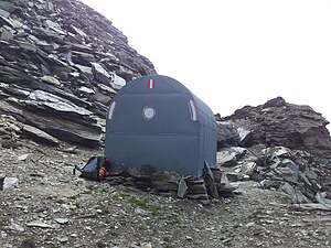
Otto Umlauft Bivouac
| Otto-Umlauft-Bivouac ÖAV bivouac box category I |
||
|---|---|---|
| location | Krumlkeeskopfscharte; Carinthia , Austria | |
| Mountain range | Goldberg Group | |
| Geographical location: | 47 ° 4 '51 " N , 12 ° 55' 14" E | |
| Altitude | 2987 m | |
|
|
||
| owner | Alpenverein Klagenfurt of the PES | |
| Built | 1973 | |
| Construction type | Bivouac box ; Corrugated iron | |
| accommodation | 0 beds, 8 camps | |
| Winter room | open | |
| Hut directory | ÖAV DAV | |
The Otto-Umlauft-Bivouac is a bivouac box on the Krumlkeeskopfscharte in the Goldberg group , part of the Hohe Tauern in Austria . The bivouac is located at 2987 m directly on the main Alpine ridge between the Krumlkeeskopf and the Arlthöhe. It is operated by the Klagenfurt section of the Austrian Alpine Club , is in very good condition (summer 2012) and offers space for eight people.
history
The bivouac was set up on the occasion of the establishment of the Klagenfurt Jubiläumsweg (100th anniversary of the Klagenfurt Section) by Otto Umlauft on October 12, 1973, as it made sense as a temporary accommodation for the walk along the path. The bivouac box was prefabricated and installed using a helicopter.
Approaches
The bivouac can be reached from Heiligenblut am Großglockner via the great Fleißtal in about five hours, from Kolm-Saigurn via the Hocharn in about six hours and from the Hochtor ( Großglockner High Alpine Road ) in about seven hours.
Tour possibilities
- Krumlkeeskopf in 1 hour
- Hocharn in 1½ hours
- High sun view in 4½ hours
- Hochtor
cards
- Alpine club map sheet 42, 1: 25,000, Sonnblick
- Federal Office for Metrology and Surveying, Sheet 153

