
Oytal

The Oytal is a valley in the Oberallgäu district in the Allgäu Alps that branches off from the Trettachtal in an easterly direction with the Oybach near Gruben in Markt Oberstdorf .
The Dr.-Hohenadl-Weg leads along the Oybach . A road, which is only approved for motor vehicle traffic, leads from Oberstdorf approx. 5 km to half of the valley to the Oytalhaus at an altitude of 1010 m . The Untere Gutenalp ( 1048 m ) and the Käseralp ( 1405 m ) can be reached from the Oytalhaus . There are snack stations there in summer . On the way there, the Stuibenfall, a striking, free-standing waterfall, is passed. Below the Stuibenfall, the Oybach often seeps into the creek bed and only reappears below the Oytalhaus.
The experienced hiker can reach the Nebelhorn ( 2224 m ) via the Oytal in 6 to 8 hours via the high alpine and well-known glide path. Other hiking routes lead over the Laufbacher Eck ( 2178 m ), the Kleinen ( 2096 m ) and Großer Seekopf ( 2085 m ) and the Schochen ( 2100 m ) or to the high Seealpsee ( 1628 m ). Alpine experience, surefootedness and a head for heights as well as ankle-high mountain boots with a good treaded sole are basic requirements for these activities.
photos

Dried up river bed of the Oybach
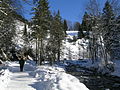
Oytal and Oybach in winter
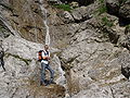
One of the numerous waterfalls in the Oytal


Web links
Coordinates: 47 ° 23 ' N , 10 ° 19' E