Seealpsee (Allgäu Alps)
| Seealpsee | ||
|---|---|---|

|
||
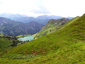
| Seealpsee from the northeast with Seeköpfle | ||
| Geographical location | Allgäu Alps ( Bavaria , Germany) | |
| Drain | Oybach | |
| Data | ||
| Coordinates | 47 ° 23 '57 " N , 10 ° 20' 22" E | |
|
|
||
| Altitude above sea level | 1622 m | |
| surface | 7.5 ha | |
| Maximum depth | 42 m | |
The Seealpsee is a high mountain lake at 1622 meters above the Oy Valley in the Allgäu Alps .
The approx. 75,000 m² large lake drains over the Seebach into the Oybach and is located in the Thumb Group on the southern slope of the Schattenberg ridge , which towers over it 200 m. To the east are the peaks of the Großer and Kleiner Seekopf , and towards the Oytal only a low rubble bar borders the lake.
The hiking trail from the Oytal-Haus to the Edmund-Probst-Haus at the Nebelhornbahn mountain station runs 60 m above the Seealpsee along its eastern flank. The part that bypasses the steep sea walls to the east is known as the glide path .
The cirque and the lake are designated as valuable geotopes by the Bavarian State Office for the Environment (geotope number: 780R002).
See also
Individual evidence
- ^ Bavarian State Office for the Environment, Geotope Seealpsee ESE von Oberstdorf (accessed on October 8, 2017).
