
Oybach
| Oybach | ||
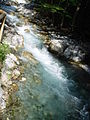
 The Oybach near Gruben in winter |
||
| Data | ||
| Water code | DE : 114214 | |
| location | District of Oberallgäu | |
| River system | Danube | |
| Drain over | Trettach → Iller → Danube → Black Sea | |
| source | as Schartenbach on the northwest slope of the Jochspitze 47 ° 21 '18 " N , 10 ° 22' 23" E |
|
| Source height | approx. 1820 m | |
| muzzle | South of Oberstdorf in the Trettach Coordinates: 47 ° 23 '29 " N , 10 ° 17' 37" E 47 ° 23 '29 " N , 10 ° 17' 37" E |
|
| Mouth height | approx. 850 m | |
| Height difference | approx. 970 m | |
| Bottom slope | approx. 10% | |
| length | 9.4 km (with Schartenbach and Stuibenbach) | |
The Oybach is a 10 km long right tributary of the Trettach . It runs as a mountain river in the Oytal near Oberstdorf in the Allgäu Alps . Its valley is the habitat of numerous rare animals and plants and is therefore one of the special valleys in the Alps .
course
It rises as a Schartenbach on the northwest slope of the Jochspitze and forms the Stuibenbach in the rear Oytal together with several other source brooks , which merges into the Oybach after the imposing Stuibenfall . The Oybach offers a unique natural spectacle. The river bed is completely dry for a long stretch down the valley in summer, although plenty of water flows into the valley from the mountain slopes. The reason for this is the extremely permeable limestone soil . When the water level is normal, the water flows underground in a broad stream down the valley. The river only reappears below the Oytalhaus. Numerous "sources" let the river rise to a considerable mountain river within a short time.
Tributaries
- Stuibenbach (upper course)
- Laufbach (right)
- Seebach (right)
literature
- Wilfried Bahnmüller (Ed.): Right hiking, Allgäu and Ammergau Alps . DuMont Buchverlag, Cologne 1993
Picture gallery
Rapids

View of the Oytal

Dried up river bed

Flora on the bank


Web links
Individual evidence
- ↑ GeoFachDatenAtlas and water services of the Bavarian State Office for the Environment