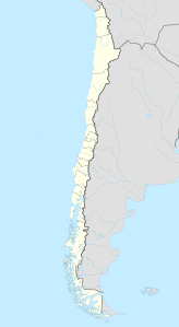
Palpana
| Palpana | ||
|---|---|---|
|
The Palpana volcano seen from the summit of Ollagüe (top center). |
||
| height | 6023 m | |
| location | Antofagasta region , Chile | |
| Mountains | To the | |
| Dominance | 36.55 km → Aucanquilcha | |
| Coordinates | 21 ° 32 '49 " S , 68 ° 31' 22" W | |
|
|
||
| Type | Stratovolcano | |
| First ascent | 1977 | |
The Palpana is a 6023 m high volcano in the western cordillera of the Andes in northern Chile near the border with Bolivia .
The volcano lies between the Río Loa and the salt pans Salar de Ascotán and Salar de Carcote to the east and is part of the Reserva Nacional del Alto Loa . The first ascent was made in 1977 by J. Ambrus and J. Sepúlveda.
Web links
Individual evidence
- ↑ Palpana on peakbagger.com
- ↑ Volcán Palpana. andeshandbook.org, accessed October 18, 2015 (Spanish).

