Parchim-Meyenburg sand areas

The Parchim-Meyenburg sand areas form the most northerly natural spatial unit of the North Brandenburg plateau and hill country .
location
The area extends from Meyenburg and Putlitz an der Stepenitz in the south over Ganzlin in the east to northwest of Parchim . Neighboring landscapes are the Ruhner Berge and the Prignitz in the south, the southwestern foreland of the Mecklenburg Lake District in the northwest and the Mecklenburg Lake District in the northeast.
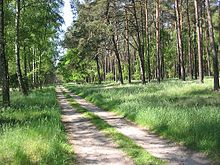
Geomorphologically , the flat, undulating Parchim-Meyenburg sand areas were created in the Glacial Vistula . In the east there are also ground moraines that have been partially silted up with a higher proportion of clay. Most of the land is used for agriculture. Especially in the south and west, however, soils for arable farming are of poor or insufficient quality. On this heather there are pine forests used for forestry next to extensive grasslands such as the Marienfließ nature reserve , which extends in both the Mecklenburg and Brandenburg parts of the landscape. Grassland is used on the rivers, of which the Elde is the largest .
In the south, parts of the landscape are protected in their character as part of the Brandenburg landscape protection area Agrarlandschaft Prignitz-Stepenitz with its numerous structural elements such as avenues , hedges, ditches and piles of stones . The preservation of the habitat of numerous bird species is a focus, for example the protection of the ortolan .
literature
- Eberhard Scholz: The natural spatial structure of Brandenburg . Pedagogical District Cabinet, Potsdam 1962, p. 79 .
Web links
- Landscape profile for the Parchim-Meyenburg sand areas of the Federal Agency for Nature Conservation
Individual evidence
- ↑ Ordinance on the landscape protection area "Agrarlandschaft Prignitz-Stepenitz". From December 15, 2008. State government of Brandenburg, accessed on January 10, 2013 .