Parvomay Neck
Coordinates: 62 ° 30 ′ S , 59 ° 45 ′ W

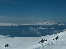
View from Livingston Island over Moon Bay , Half Moon Island and McFarlane Strait to the Parvomay Neck (in the background: Robert Island )
The Parvomay Neck (English; Bulgarian Първомайски провлак Parwomajski prowlak ) is a 5 km long and between 1.55 and 3.5 km wide isthmus of Greenwich Island in the archipelago of the South Shetland Islands . It connects the northwest with the southeast part of the island and lies between Discovery Bay in the northeast and Shopski Cove and Yankee Harbor in the southwest.
Bulgarian scientists mapped it in 2009. The Bulgarian Commission for Antarctic Geographical Names named it in 2010 after the town of Parwomaj in southern Bulgaria .
Web links
- Parvomay Neck in the Composite Gazetteer of Antarctica (English)

