
Marloffstein Pass
| Marloffstein Pass | |||
|---|---|---|---|
 Pass summit, view in north direction |
|||
| Compass direction | North | south | |
| Pass height | 390 m above sea level NN | ||
| state | Bavaria | ||
| Valley locations | Langensendelbach | Savings village | |
| expansion | State Road St 2242 | ||
| Mountains | Franconian Alb | ||
| Map (Bavaria) | |||
|
|||
| Coordinates | 49 ° 37 '17 " N , 11 ° 3' 56" E | ||

The Marloffstein pass is 390 m above sea level. NN high hills in the foreland of the Franconian Alb between the communities Langensendelbach and Spardorf . The top of the pass is in the area of the municipality of Marloffstein .
Location and surroundings
In addition to the water tower, which can be seen from afar, there are several land monuments at the top of the pass . To the west of the pass is the former Marloffstein clay pit.
An alternative route of the Way of St. James between Forchheim and Nuremberg leads over the Marloffstein Pass.

Information sign at the top of the pass

Wayside shrine from 1787
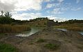
Marloffstein clay pit


Web links and sources
- Pass Marloffstein at quaeldich.de
- Pass Marloffstein at franken-tour.de
- Elevation profile from Langensendelbach
- Elevation profile from Spardorf
Individual evidence
- ↑ Map services ( Memento of the original from December 19, 2012 in the Internet Archive ) Info: The archive link has been inserted automatically and has not yet been checked. Please check the original and archive link according to the instructions and then remove this notice. of the BfN
- ↑ http://www.franken-tour.de/radwanderungen/jakobsweg_in_franken/forchheim_nuernberg/forchheim-nach-nuernberg.html (accessed on March 26, 2010)