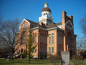
Paulding (Ohio)
| Paulding | ||
|---|---|---|
 Courthouse of Paulding County in Paulding |
||
| Location in Ohio | ||
|
|
||
| Basic data | ||
| Foundation : | 1848 | |
| State : | United States | |
| State : | Ohio | |
| County : | Paulding County | |
| Coordinates : | 41 ° 9 ′ N , 84 ° 35 ′ W | |
| Time zone : | Eastern ( UTC − 5 / −4 ) | |
| Residents : | 3,595 (as of: 2000) | |
| Population density : | 609.3 inhabitants per km 2 | |
| Area : | 6.2 km 2 (approx. 2 mi 2 ) of which 5.9 km 2 (approx. 2 mi 2 ) is land |
|
| Height : | 219 m | |
| Postal code : | 45879 | |
| Area code : | +1 419 | |
| FIPS : | 39-61252 | |
| GNIS ID : | 1044331 | |
Paulding is a municipality and administrative headquarters ( the county seat ) of Paulding County , Ohio , United States . Paulding is mainly in the Paulding Township . The place had 3595 inhabitants at the 2000 census.
geography
Paulding is located at the confluence of Ohio State Route 111 with US Highway 127 and the end point of Ohio State Route 500 . The community was on the Cincinnati Northern Railroad , but this railroad line was disbanded in the 1980s. There is also a small airport, Paulding Airport, about 3 km northeast of the center of the municipality ( FAA code 2H8).
history
Paulding, founded in 1848, is located in the middle of the county. In 1872 Paulding was incorporated as a separate community.
Paulding is named after the civil war hero John Paulding, like the county . Until the late 19th century, this region was swampy and covered by large expanses of water. The village began as a settlement of two families and grew to 454 inhabitants by 1880. When large parts of the Great Black Swamp were successfully drained and made usable for agriculture, the population quickly rose to over 1,800.
A wood processing industry was established in Paulding that used the resources of the surrounding forests.
