Petare
| Petare | ||
|---|---|---|
|
Coordinates: 10 ° 29 ′ N , 66 ° 49 ′ W Petare on the map of Venezuela
|
||
| Basic data | ||
| Country | Venezuela | |
| State | Miranda | |
| City foundation | February 17, 1621 | |
| Residents | 412,756 (2007) | |
| Detailed data | ||
| surface | 146 km 2 | |
| Population density | 2.827 inhabitants / km 2 | |
| height | 820 m | |
| Post Code | 1073 | |
| prefix | 0212 | |
| Time zone | UTC −4.5 | |
| City Presidency | Carlos Ocariz ( Primero Justicia ) | |
| Website | ||
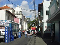
Petare is a Venezuelan city in the northern state of Miranda and at the same time the capital of the Municipio Sucre with 412,756 (2007) inhabitants, 640,762 in the Municipio.
The city was founded in 1621 under the name Dulce Nombre de Jesús de Petare and is now located in the metropolitan area of Caracas .
Petare has two universities and a television station. The strong population growth led to the formation of many slums . The crime is high.
sons and daughters of the town
- Rosmit Mantilla (* 1982), Venezuelan politician
Individual evidence
- ↑ http://www.ine.gob.ve/secciones/secciones.asp ( page no longer available , search in web archives ) Info: The link was automatically marked as defective. Please check the link according to the instructions and then remove this notice.
- ↑ http://www.citypopulation.de/Venezuela.html
Web links
Commons : Petare - collection of images, videos and audio files


