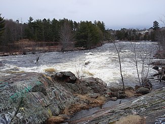
Petawawa River
| Petawawa River | ||
|
The river at the city of Petawawa |
||
| Data | ||
| location | Nipissing District , Renfrew County in Ontario, Canada | |
| River system | Saint Lawrence River | |
| Drain over | Ottawa River → Saint Lawrence River → Atlantic Ocean | |
| origin |
Butt Lake 45 ° 40 ′ 49 ″ N , 78 ° 57 ′ 2 ″ W. |
|
| muzzle | at Petawawa in the Ottawa River coordinates: 45 ° 54 ′ 39 " N , 77 ° 15 ′ 33" W 45 ° 54 ′ 39 " N , 77 ° 15 ′ 33" W
|
|
| length | 187 km | |
| Catchment area | 4200 km² | |
| Drain |
MQ |
45 m³ / s |
| Left tributaries | Nipissing River , North River | |
| Right tributaries | Barron River | |
| Flowing lakes | Burntroot Lake , Catfish Lake , Cedar Lake , Radiant Lake , Lake Traverse | |
| Small towns | Petawawa | |
| Communities | Brent | |
The Petawawa River is a 187 km long river in eastern Ontario , Canada.
It has its source in Butt Lake , in the north of Algonquin Provincial Park , flows in an easterly direction and flows into the Ottawa River at Petawawa . It drains an area of 4200 km². It flows through a number of lakes, including Cedar Lake and Radiant Lake . Its name comes from the Algonquin language and means "where you can hear such a noise", referring to its many rapids. From the end of the 19th century until the 1960s, the river was used for rafting . Because of its white water , the Petawawa is very popular with canoeists .
Part of the Petawawa River runs through the Ottawa-Bonnechere Trench , a 175 million year old rift valley .
Tributaries of the Petawawa River include:
- Barron River
- Crow River
- Little Madawaska River
- Nipissing River flows into Cedar Lake
- North River flows into Radiant Lake
