Petit Raffray
Coordinates: 20 ° 1 ′ S , 57 ° 37 ′ E
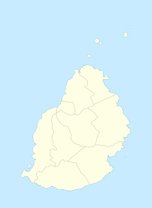
Petit Raffray is a place ("Village") in the north of Mauritius . It is part of the Rivière du Rempart district and administratively belongs to the Village Council Area (VCA) Petit Raffray. At the 2011 census, the place had 9,254 inhabitants.
The place goes back to a domain that Guillaume Olivier Rafffray (1757-1837) acquired. In 1844 Jean Rose Daruty built a sugar factory, which was closed again in 1865. From 1870 the domain was parceled out and sold to smallholders. In 1989 Cap Malheureux was separated from the VCA and declared an independent VCA.
literature
- Benjamin Moutou: Pamplemousses - Riviére du Rempart - Quatre siécles d'histoire, 2006, ISBN 978-99903-992-9-5 , SS 311-312
Individual evidence
- ↑ Statistics Mauritius: Housing and population census 2011 , Volume II: Demographic and fertility characteristics , p. 71, statsmauritius.govmu.org (PDF)
