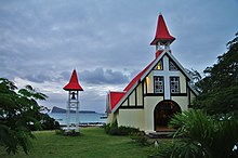
Cap Malheureux
| Vacoas-Phoenix | ||
|---|---|---|
| Basic data | ||
| Region: | Rivière du Rempart | |
| Coordinates: | 19 ° 59 ′ S , 57 ° 37 ′ E | |
| Height: | 7 ü. d. M. | |
| Founding year: | N / A | |
| Surface: | NA km² | |
| Residents: | 4,427 | |
| Time zone: | UTC +4 | |
| Telephone code: | N / A | |
| Website: | ||
| Geographical location in Mauritius | ||
|
|
||
Cap Malheureux is a place in the Rivière du Rempart district of Mauritius . Administratively it belongs to the Village Council Area (VCA) Cap Malheureux, which also includes the Calodyne district. At the 2011 census, the place had 5070 inhabitants. Cap Malheureux is also the name of the northern cape of the island on the territory of the municipality. The cape is known for its Catholic chapel with a striking red roof, which is a frequent motif for postcards or photographs. This chapel Chapelle Notre-Dame-Auxiliatrice belongs to the parish of Saint Michel in Grand Gaube .
In 1810, the British troops landed in the Mauritius campaign under the command of Admiral Albemarle Bertie on November 29, 1810 at 8:30 a.m. about 4 km south of Cap Malheureux, without encountering major resistance. Cap Malheureux was also not affected by the further course of the invasion until the French surrendered on December 3, 1810.
The tower of the windmill of the Belle Rive sugar factory in the municipality was declared a cultural monument in 1951. The municipality's old cemetery is one of the oldest in the north of the island. The oldest grave here dates from 1842.
A Catholic school had existed in the village since 1925. Today's public school has existed since 1940. Until 1989 the place was administratively part of the Petit Raffray VCA and has been an independent municipality since then.
literature
- Abdool Rashid Nujjoo: History of Grand Bay: little village facing an ocean, 2007, pp. 73-75
Web links
Individual evidence
- ↑ Statistics Mauritius: Housing and population census 2011 , Volume II: Demographic and fertility characteristics , p. 71, statsmauritius.govmu.org (PDF)
- ^ Website of the parish
- ^ Save our heritage: Tour du moulin à vent de Belle Rive . Website about cultural monuments in Mauritius

