
Grand Baie
| Grand Baie | |||
|---|---|---|---|

|
|||
| Basic data | |||
| Region: | Pamplemousses (district) | ||
| Coordinates: | 20 ° 1 '1 " S , 57 ° 34' 43" O | ||
| Height: | 6 m above sea level d. M. | ||
| Founding year: | N / A | ||
| Surface: | N / A | ||
| Residents: | 11,910 | ||
| Time zone: | UTC +4 | ||
| Telephone code : | N / A | ||
| City structure: | N / A | ||
| Geographical location in Mauritius | |||
|
|||

Grand Baie is a place ("Village") on Mauritius .
The eastern part of Grand Baie belongs to the Rivière du Rempart district , the western part is in the Pamplemousses district . At the 2011 census, the place had 11,910 inhabitants (of which 2.507 in the Pampelmousses district and 9.403 in the Rivière du Rempart district), the population density was 793.5 inhabitants per square kilometer. Both parts are administratively part of the Village Council Area Grand Baie, which also includes the districts of Pointe aux Canonniers and Pereybère .
history
In 1642, when Adriaan Vanderstel was the Dutch governor of Mauritius, Abel Tasman led an expedition around the north of the island. On the map created at that time, today's Gand Baie was referred to as “De Bogt Zonder Einde” (Bay without End).
The area of today's Grand Baie was (like the whole island) uninhabited before the arrival of the Dutch. That changed only slowly after the French took over the colony. In 1777 Jaques Le Roux Kermorseven acquired part of the 8,896 arpent of the Triolet agricultural property , which also comprised the area of today's Grand Baie, and began cultivating it. A map by Charles Grant Viscount de Vaux from 1801 shows three main settlement areas: Pointe aux Canonniers Pointe des Vaqquois and Grand Baie.
In 1810, the British troops landed in the Mauritius campaign under the command of Admiral Albemarle Bertie on November 29, 1810 at 8:30 a.m. about 4 km north of Grand Baie. At 2:30 p.m. the troops took Grand Baie without encountering major resistance. Grand Baie was not affected by the further course of the invasion until the surrender of the French on December 3, 1810.
The area of today's Grand Baie consisted of a number of sugar cane plantations. The workers lived in camps on these plantations; there were only rudimentary settlements in the true sense of the word. In 1880 the sugar price collapsed on world markets. As a result, large parts of the previously cultivated areas in Mauritius were set aside. The workers took over these areas in small plots and cultivated the area on their own account. From 1880 to 1920 the previous plantation structure was dissolved and villages, including today's Grand Baie, were created. The inhabitants of Grand Baies came mainly from the plantations Sottise, Mare Séche, Daruty, Mont Mascal, Mont Choisy and La Salette.
The previous plantation workers had already lived together on the plantations according to ethnic or religious groups. They settled in Grand Baie from 1880, also separated according to ethnic group. These structures are still recognizable today (also at the locations of the respective places of worship). The Muslims settled in The Vale, the Hindus from North India in the upper part of the city around Raquette Road and the Tamils in the lower end of the village.
In 1960 the cyclones Alex and Carol devastated the place. Carol in particular hit Grand Baie hard: 80% of the buildings were destroyed. The government provided land and credit for reconstruction. The resulting part of the village is popularly known as "Camp Carol".
tourism
Grand Baie (German: Big Bay) is a center of bathing tourism on the north coast of Mauritius. The Grand Baie is a bay on the north side, which is a natural harbor for small boats due to its location surrounded by land on three sides. Due to the shallow water and the offshore reefs it is not navigable for ships. The coastline of the place itself at the head of the bay and the surrounding shoreline are built up with hotels, holiday homes and restaurants. There is a public beach in the city center.
Grand Baie is at the end of the M2 motorway and is around 27 km away from the capital Port Louis via this motorway. At the end of the motorway there is one of the two shopping centers in town (La Croisette; the other is Super U). In the center of the village, the covered market, the Bazar de Grand Baie, mainly sells tourist products.
There are three public parks: Domaine Les Pailles, Casela Nature & Leisure Park and Domaine du Chasseur.
religion
Christianity

In 1777 the island was divided into cantons for church purposes. The Canton Grand Baie was formed in the north of the island . However, the first Christian chapel was not built in Grand Baie itself until 1843: the landowner Louis Victor Mazery had the Notre-Dame-de-Bon-Secours chapel ( Mariahilfkirche ) built on his Mare Sèche plantation . The Christian community at that time numbered 147 Catholics. The main church of the parish was the Franciscan Church in Pamplemousses .
In 1858 the number of Catholics in the canton had reached 760, 240 of whom lived in Grand Baie itself. The Mazery couple tried to build a parish church. Their two children Adélia and Louis had died in childhood; They therefore use their financial resources for the church community. On September 21, 1864, a separate parish of Notre-Dame-des-Sept-Douleurs was established in Grand Baie and Dom Stuart was appointed first pastor. The parish included the chapels of Notre-Dame-de-Bon-Secours, Mare Sèche, Saint-Julien, Triolet and Bon-Pasteur in Cap Malheureux .
After the congregation had grown a lot, a church was missing in the center of the village. In 1834, Pastor Abbot Albert Glorieux had a chapel built in the town center. The wooden chapel was 45 feet long and 18 feet wide and opened on August 5, 1935. It was dedicated to Saints Anges Gardiens ( to the Holy Guardian Angels ).
This chapel was destroyed in a cyclone in 1945 . In 1959, today's parish church was built directly on the coast on the B13. According to plans by the architect M. Jac Desmarais, a modern church was built, which is almost a roof-top house . Like many churches in Mauritius, the roof beams are open. The colorful stained glass windows show maritime motifs. The church was consecrated on August 24, 1959.
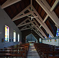
inner space

Church window

Holy water bowl


Hinduism
In the 1880s, a Kalimaye , a walled square with seven stones in the middle representing deities, was built on Vingt Pieds Road. A second Kalimaye and a Baitka (a Hindu evening school) called Surija Mukhi were added next to the Government School. A second baitka called Arya Mandir was added around 1953 .
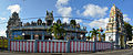
In the center of the village there is a small Hindu temple, Shiv Kalyannath Mandir, which is dedicated to Shiva . Larger and more magnificent is the Hindu temple Vadapazhanee Murugan Kovil, which is located on the coastal road about one kilometer outside the city center. The temple, dedicated to the god Murugan , was built in 1967.
In 1930 the crematorium was built for the Hindis.
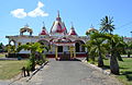
Shiv Kalyannath Mandir
Vadapazhanee Murugan Kovil

Gopuram of Vadapazhanee Murugan Kovil


Islam
Muslims have lived in Grand Baie since 1860. Around 1930 the first madrasa was built on the grounds of the Toofanee family . After the Toofanee family moved to Rose Hill in 1843 , a new wooden madrasa was built on government-provided land in 1844. In 1957 the mosque Ronaq-ul Islam Sunnee Mosjid was built. This is opposite the Catholic Church on the land side of the B13. In 2000 there were around 300 Muslims in Grand Baie.
schools

In 1839 the first school was opened in Grand Baie. It was a church school of the Society for the Propagation of Gospel (SFPG), represented in Grand Baie by Chaplain Denny.
A little later it was regulated by law that the schools should be subject to the control of the state Education Committee. In 1843 the government therefore opened three state schools in Port Louis , Pamplemousses and Grand Baie. The government appointed a Protestant couple as teachers. This led to bitter resistance from the Catholic population, led by the Mazery couple. However, they could not bring about any change in the school question and therefore concentrated on building churches.
In 1892 the school had three teachers and 80 students (49 boys and 31 girls). In the 1950s the number of pupils at the Grand Baie Government School increased significantly, as the children from Cap Malheureux, The Vale and Fond du Sac now also attended the school. In 1856 the school was expanded and now had six classrooms.
Grand Baie is also the seat of the Adolphe de Plevitz State Secondary School , which is named after the German social reformer Adolphe de Plevitz (Alfred von Plevitz).
Pointe aux Canonniers
Pointe aux Canonniers is a district of Grand Baie (West).
Pointe aux Canonniers is located between Grand Baie in the northeast and Trou aux Biches in the south on the northwest coast of Mauritius on a small headland. The town itself consists primarily of a section of the coastal road B13 (the Royal Road) built with shops, restaurants and residential properties, which cuts the headland here and a narrow road that follows the coastline (the Costal Road). At the top of the headland are the Le Canonnier and Club Med hotels and the Mont Choisy public beach, which are part of the municipality.
Fort and lighthouse

In 1750, the French colonial power built a fort on the headland. 50 French soldiers were stationed here. The actual fort was built on an artificial hill 80 by 80 meters and a height of 25 meters. Upstream was a bastion for the artillery stationed here. The foundation walls of the bastion and the actual hill (on which a restaurant now stands) are still preserved. The powder store outside the fort, which was built in 1764, has also been preserved. The thick basalt walls and the arched brick ceiling were designed to limit the consequences of a powder explosion and have promoted preservation to this day.
The largest preserved building in the complex is a watchtower. This is built from basalt stones. Lime mortar was used as a connection. The lime required was burned from the corals of the nearby reef. In 1846 a glass dome was added to the tower and operated as a lighthouse until 1932. The watchtower / lighthouse is a listed building .
The site was then privately owned and was fallow. With the development of tourism, it also made sense to use this 7.5 hectare site for tourism. The Hotel Le Canonnier opened on October 22, 1990. The 4-star hotel with 278 rooms integrated the old fort into its grounds, which also includes a number of cannons cast in 1732.
Quarantine station

With the abolition of slavery in 1835, the recruitment of contract workers from India and other Asian countries began. Over the next 80 years, more than 400,000 people immigrated. The central initial reception center in Port Louis , Aapravasi Ghat, is now a UNESCO World Heritage Site . An important part of the admission procedure was the health check. Contract workers who may have been afflicted with infectious diseases were not taken to their future employers, but initially to a quarantine station. This was located in Pointe aux Canonniers on the site of the Club Med, which was built in 1972. With the end of the contract labor system at the beginning of the 20th century, the importance of the station also ended.
Only a few parts of the station have survived. This includes the former quay where the sick were landed. Even if it looks more like a groyne than a quay due to the time and the tropical storms, it can still be recognized. The tomb of a Scottish quarantine doctor by the name of Goumany, who died here in 1889 at the age of 30, stands in the garden of Club Med. An inscription in which an officer of the quarantine station has immortalized himself has been preserved on the beach section of Le Canonnier.
Mont Choisy

Mont Choisy is a four-kilometer public beach. It is located south of Club Med and north of Trou aux Biches. The sandy beach is lined with a grove of ironwood trees. It is a popular local recreation area for the population and is a destination for thousands of locals, especially on Hindu holidays.
The name is derived from a general of the French East India Campany named Mont Choisy. The site belonged to a plantation that was created in 1795 when Pierre Maillard acquired 5506 Arpents of the Triolet plantation. After his death this plantation was divided again. This is how the Sottise and Mont Choisy Estate came into being. From 1813 onwards it operated as Société de Mont Choisy . At first only small parts were cultivated. The complaint against the plantation owner Henry Felix Poulin in 1871 is significant for the island's history. Poulin was considered a cruel and inhumane person. On November 23, 1864, he was sentenced to three months in prison for an attack on an Indian woman (but released after three weeks). In 1871, 67 workers filed a complaint against Poulin because he had not paid the agreed wages. The court did not pursue this complaint; instead the workers were arrested. As a result, protests broke out across the country. Adolphe de Plevitz, after whom the secondary school in Grand Baie is named, collected 9,400 signatures for a petition and set up a royal commission of inquiry.
On September 10, 1933, the first aircraft landed in Mauritius in the fields of Mont Choisy. To commemorate this flight from Reunion to Mauritius, a monument was erected next to the football field. In 1950 the British government decided to build an airport in Mont Choisy. After the work began, the project was quickly abandoned because the subsoil was too soft.

"La Croisette" shopping center

"Super U" shopping center


Pereybère
Pereybère is the district on the eastern side of the bay. In 1845 Charles Peyrebère (1816-1883) acquired a third of the Grand Baie estate. In 1915 the Grand Baie property was actually divided. La Salette SE (sugar estate) had an area of 629 arpents and Pereybère SE an area of 703 arpents. In 1929, Georges Castel acquired the Pereybère SE. At the latest during this time, the name of the area, which was changed from Peyrebère to Pereybère by shifting sounds, was also official.
Pereybère beach was overgrown and unused until the early 1940s. Then it was cleared and released to the public. In 1946, Georges Castel sold the property that was now parceled out and the non-agricultural part developed into today's residential area. With the advent of tourism, the coastal strip became the location of large hotels such as “La Mauricia”.
literature
- Abdool Rashid Nujjoo: History of Grand Bay: little village facing an ocean, 2007
Web links
- National Heritage Fund Act (No. 40) of 2003 with the evidence for the mentioned monuments, online
- Archaeological excavations in Mont Choisy
Individual evidence
- ↑ Statistics Mauritius: Housing and population census 2011 , Volume II: Demographic and fertility characteristics , p. 71, statsmauritius.govmu.org (PDF): the values for both districts must be added.
Amitié (West) | Arsenal | Baie du Tombeau | Belle Vue Maurel (North) | Calebasses | Congomah | Crève Coeur | D'Épinay | Fond du Sac | Grand Baie (West) | Le Hochet | Long Mountain | Mapou (South) | Morcellement St. André | Notre Dame | Pamplemousses | Piton (West) | Plaine des Papayes | Pointe aux Piments | Terre Rouge | Triolet | Villebague (north-west)
Amaury (North) | Amitié (East) | Belle Vue Maurel (South) | Brisée Verdière (North) | Cap Malheureux | Cottage | Espérance Trébuchet | Goodlands | Grand Baie (East) | Grand Gaube | Mapou (north) | Petit Raffray | Piton (east) | Plaines des Roches (North) | Poudre d'Or Hamlet | Poudre d'Or | Rivière du Rempart | Roche Terre | Roches Noires (North) | The Vale | Villebague (East)