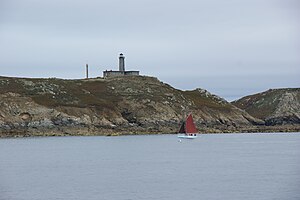
Phare des Sept-Îles
| Phare des Sept-Îles | ||
|---|---|---|
| Place: |
|
|
| Location: | Cotes-d'Armor , Brittany , France | |
| Geographical location: | 48 ° 52 '43.4 " N , 3 ° 29' 23.8" W | |
| Height of tower base: | 39 m | |
| Fire carrier height : | 20 m | |
| Fire height : | 59 m | |
|
|
||
| Identifier : | Fl (3) W.15s | |
| Scope knows: | 24 nm (44.4 km ) | |
| Operating mode: | Halogen 650 W | |
| Function: | Orientation fire | |
| Operating time: | 1835–1944 and since 1952 | |

Lighthouse as seen from Phare de Ploumanac'h (in the foreground)
Phare des Sept-Îles (German: 'Lighthouse of the Seven Islands') is the name of a lighthouse built in 1887 on the Île aux Moines ( Breton : Enez ar Breur or Jentilez) in the Sept Îles archipelago . The archipelago belongs to the Côtes-d'Armor department in Brittany . It has a range of 24 nautical miles . It is located next to a fortress ruin from the 18th century, whose job it was to prevent smuggling and piracy .
history
- The originally round tower was put into operation in 1835 and replaced by a new building five meters higher in 1854. Destroyed in 1944, it was replaced until 1949 and reopened in 1952.
- In 1952, France's largest wind turbine was installed in a lighthouse.
- The Sept Îles archipelago has been a bird sanctuary since 1912 .
- As one of the last lighthouses at sea, it was automated in 2007.
See also
Web links
Commons : Phare des Sept-Îles - Collection of images, videos and audio files

