| Surname
|
region
|
Waters
|
position
|
Year of construction (s)
|
Tower height
|
Fire height
|
Identifier
|
image
|
|
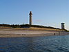
Aiguillon!Phare de l'Aiguillon
|
Pays de la Loire
|
Loire estuary
|
47 ° 14 '32.3 " N , 2 ° 15' 47.7" W.47.2423 -2.26324
|
1756
|
22 m
|
27 m
|
Oc (3) WR.10s
|

|
|
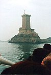
Amedee!Phare Amédée
|
New Caledonia
|
Coral sea
|
22 ° 28 '38.5 " S , 166 ° 28' 4.6" O-22.47737 166.46795
|
1865
|
56 m
|
55 m
|
Fl (2) W.15s
|

|
|
Armandeche!Phare de l'Armandèche
|
Pays de la Loire
|
Biscay
|
46 ° 29 '23.5 " N , 1 ° 48' 17.2" W.46.48987 -1.80478
|
1968
|
39 m
|
42 m
|
Fl (2 + 1) W.15s
|

|
|
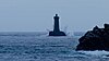
Ar Men!Phare d'Ar-Men
|
Brittany
|
Iroise
|
48 ° 3 ′ 1 ″ N , 4 ° 59 ′ 50 ″ W.48.05028 -4.99722
|
1881
|
34 m
|
29 m
|
Fl (3) W.20s
|

|
|
Baleineaux!Phare des Baleineaux
|
Nouvelle-Aquitaine
|
Biscay
|
46 ° 15 ′ 49.4 " N , 1 ° 35 ′ 12" W.46.26372 -1.58667
|
1854
|
31 m
|
31 m
|
Oc (2) W.6s
|

|
|
Baleines!Phare des Baleines
|
Nouvelle-Aquitaine
|
Biscay
|
46 ° 14 '39.1 " N , 1 ° 33' 40" W.46.2442 -1.56112
|
1682/1854
|
57 m
|
53 m
|
Fl (4) W.15s
|
|
|
Balue!Phare de la Balue
|
Brittany
|
English Channel
|
48 ° 37 '35.8 " N , 2 ° 0' 13.9" W.48.62662 -2.00386
|
1868/1948
|
37 m
|
74 m
|
FG
|

|
|
Bas sablons!Phare des Bas-Sablons
|
Brittany
|
English Channel
|
48 ° 38 '10 " N , 2 ° 1' 18.2" W.48.6361 -2.02172
|
1865
|
19 m
|
20 m
|
FG
|

|
|
Bel-Air!Phare de Bel-Air
|
Reunion
|
Indian Ocean
|
20 ° 54 ′ 5.3 " S , 55 ° 36 ′ 7.2" E-20.90146 55.60199
|
1845
|
20 m
|
40 m
|
Fl (3) W.15s
|

|
|
Cap Camarat!Phare du Cap Camarat
|
Provence-Alpes-Cote d'Azur
|
Mediterranean Sea
|
43 ° 12 '3.4 " N , 6 ° 40' 28.2" E43.20095 6.6745
|
1837
|
25 m
|
130 m
|
Fl (4) W.15s
|

|
|
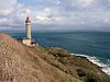
Cap Frehel!Phare du Cap Fréhel
|
Brittany
|
English Channel
|
48 ° 41 '2.8 " N , 2 ° 19" 7.5 " W.48.68412 -2.31876
|
1650/1950
|
33 m
|
85 m
|
Fl (2) W.10s
|

|
|
Cap Levi!Phare du Cap Lévi
|
Normandy
|
English Channel
|
49 ° 41 ′ 45.1 " N , 1 ° 28 ′ 23.5" W.49.69586 -1.4732
|
1858/1948
|
28 m
|
37 m
|
Fl.R.5s
|

|
|
Cassidaigne!Phare de Cassidaigne
|
Provence-Alpes-Cote d'Azur
|
Golf du Lion
|
43 ° 8 '43.9 " N , 5 ° 32' 46.3" E43.14553 5.5462
|
1834
|
23 m
|
23 m
|
Fl (2) W.6s
|

|
|
Chassiron!Phare de Chassiron
|
Nouvelle-Aquitaine
|
Biscay
|
46 ° 2 ′ 48 " N , 1 ° 24 ′ 37" W.46.04667 -1.41028
|
1685/1836
|
43 m
|
50 m
|
Fl.W.10s
|

|
|
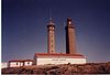
Cordouan!Phare de Cordouan
|
Nouvelle-Aquitaine
|
Gironde
|
45 ° 35 '10.9 " N , 1 ° 10' 24.1" W.45.58636 -1.17335
|
1611
|
68 m
|
70 m
|
Oc (1 + 2) HR.12s
|

|
|
Creach!Phare du Créac'h
|
Brittany
|
Celtic sea
|
48 ° 27 '33.1 " N , 5 ° 7' 44.5" W.48.4592 -5.12902
|
1863
|
55 m
|
70 m
|
Fl (2) W.10s
|

|
|
Decouverte!Tour de la Découverte
|
Brittany
|
Biscay
|
47 ° 44 '43.1 " N , 3 ° 21' 13.8" W.47.7453 -3.35382
|
1744
|
38 m
|
|
deleted
|

|
|
Dunkerque!Phare de Dunkerque
|
Hauts-de-France
|
Strait of Dover
|
51 ° 2 ′ 56 " N , 2 ° 21 ′ 51.9" E51.04888 2.36441
|
1843
|
56 m
|
59 m
|
Fl (2) W.10s
|

|
|
Eckmuhl!Phare d'Eckmühl
|
Brittany
|
Biscay
|
47 ° 47 ′ 53.5 " N , 4 ° 22 ′ 22" W.47.7982 -4.37277
|
1831/1897
|
60 m
|
65 m
|
Fl.W.5s
|

|
|
Espiguette!Phare de l'Espiguette
|
Provence-Alpes-Cote d'Azur
|
Golf du Lion
|
43 ° 29 ′ 15.6 " N , 4 ° 8 ′ 30.3" E43.48768 4.14175
|
1869
|
27 m
|
27 m
|
Fl (3) W.15s
|

|
|
Four!Phare du Four
|
Brittany
|
Celtic sea
|
48 ° 31 '23.4 " N , 4 ° 48' 18.6" W.48.52317 -4.80517
|
1874
|
28 m
|
28 m
|
Fl (5) W.15s
|
|
|
Four!Phare du Four
|
Pays de la Loire
|
Biscay
|
47 ° 17 '52.1 " N , 2 ° 38' 3.3" W.47.2978 -2.63426
|
1822
|
23 m
|
23 m
|
Fl.W.5s
|

|
|
Gatteville!Phare de Gatteville
|
Normandy
|
English Channel
|
49 ° 41 '47.1 " N , 1 ° 15' 57.2" W.49.69643 -1.26588
|
1780/1835
|
75 m
|
72 m
|
Fl (2) W.10s
|

|
|
Goulphar!Phare de Goulphar
|
Brittany
|
Biscay
|
47 ° 18 ′ 39 " N , 3 ° 13 ′ 37.5" W.47.31083 -3.22708
|
1836
|
52 m
|
87 m
|
Fl (2) W.10s
|

|
|
Grand Cardinaux!Phare des Grands Cardinaux
|
Brittany
|
Biscay
|
47 ° 19 '16.4 " N , 2 ° 50' 5.6" W.47.32122 -2.83489
|
1875
|
27 m
|
28 m
|
Fl (4) W.15s
|

|
|
Grand Charpentier!Phare du Grand-Charpentier
|
Pays de la Loire
|
Biscay
|
47 ° 12 '49.9 " N , 2 ° 19' 8.1" W.47.21387 -2.31892
|
1888
|
25 m
|
27 m
|
Q.WRG.
|

|
|
Grand Jardin!Phare du Grand Jardin
|
Brittany
|
English Channel
|
48 ° 40 '12.1 " N , 2 ° 4' 58.3" W.48.67002 -2.08285
|
1868/1949
|
38 m
|
24 m
|
Fl (2) R.10s
|

|
|
Grand Lejon!Phare du Grand Léjon
|
Brittany
|
English Channel
|
48 ° 44 '54.6 " N , 2 ° 39' 52.6" W.48.74849 -2.66461
|
1862/1881
|
30 m
|
35 m
|
Fl (5) WR.20s
|

|
|
Hague!Phare de la Hague
|
Normandy
|
English Channel
|
49 ° 43 ′ 18.7 " N , 1 ° 57 ′ 15.7" W.49.72187 -1.95437
|
1837
|
51 m
|
48 m
|
Fl.W.5s
|

|
|
Heaux de Brehat!Phare des Héaux de Bréhat
|
Brittany
|
English Channel
|
48 ° 54 '30.4 " N , 3 ° 5' 10.6" W.48.90845 -3.08628
|
1840
|
57 m
|
57 m
|
Fl (4) WRG.15s
|

|
|
Ile Batz!Phare de l'Île de Batz
|
Brittany
|
English Channel
|
48 ° 44 '43.2 " N , 4 ° 1' 36.9" W.48.74533 -4.02691
|
1705/1836
|
43 m
|
69 m
|
Fl (4) W.25s
|

|
|
Ile Lavezzi!Phare de l'Île Lavezzi
|
Corsica
|
Strait of Bonifacio
|
41 ° 20 ′ 4.5 " N , 9 ° 15 ′ 32.5" E41.33458 9.25902
|
1874
|
12 m
|
27 m
|
Oc (2) WR.6s
|

|
|
Ile Moutons!Phare de l'Île aux Moutons
|
Brittany
|
Biscay
|
47 ° 46 '28.7 " N , 4 ° 1' 39.8" W.47.77463 -4.02773
|
1879
|
17 m
|
20 m
|
Oc.WRG.6s
|

|
|
Ile being!Grand phare de l'Île de Sein
|
Brittany
|
Iroise
|
48 ° 2 '37 " N , 4 ° 52' 0.4" W.48.0436 -4.86679
|
1839/1951
|
49 m
|
53 m
|
Fl (4) W.25s
|

|
|
Ile Vierge!Phare de l'Île Vierge
|
Brittany
|
Celtic sea
|
48 ° 38 ′ 19.9 " N , 4 ° 34 ′ 3" W.48.63886 -4.5675
|
1845/1902
|
82 m
|
84 m
|
Fl.W.5s
|

|
|
Ile Yeu!Grand phare de l'Île d'Yeu
|
Pays de la Loire
|
Biscay
|
46 ° 43 '2.7 " N , 2 ° 22" 55.9 " W.46.71743 -2.38219
|
1830/1950
|
38 m
|
56 m
|
Fl.W.5s
|

|
|
Jument!Phare de la Jument
|
Brittany
|
Iroise
|
48 ° 25 ′ 20 " N , 5 ° 8 ′ 2" W.48.42223 -5.1339
|
1911
|
41 m
|
47 m
|
Fl (3) R.15s
|

|
|
Chervil!Phare de Chervil
|
Brittany
|
Biscay
|
47 ° 42 ′ 31.3 " N , 3 ° 20 ′ 14.9" W.47.70869 -3.33747
|
1854/1913
|
25 m
|
|
deleted (1989)
|

|
|
Kerdonis!Phare de Kerdonis
|
Brittany
|
Biscay
|
47 ° 18 '36.4 " N , 3 ° 3' 34.3" W.47.3101 -3.05953
|
1879
|
14 m
|
35 m
|
Fl (3) R.15s
|

|
|
Kereon!Phare de Kéréon
|
Brittany
|
Iroise
|
48 ° 26 '14.5 " N , 5 ° 1' 32.6" W.48.43735 -5.02572
|
1916
|
41 m
|
47 m
|
Oc (2 + 1) WR.24s
|

|
|
Kermorvan!Phare de Kermorvan
|
Brittany
|
Iroise
|
48 ° 21 '43.2 " N , 4 ° 47' 23.7" W.48.362 -4.78992
|
1849
|
20 m
|
20 m
|
Fl.W.5s
|

|
|
Lavezzi!Tourelle des Lavezzi
|
Corsica
|
Strait of Bonifacio
|
41 ° 19 '2.3 " N , 9 ° 15' 13" E41.3173 9.2536
|
1904
|
18 m
|
18 m
|
Fl (2) W.6s
|

|
|
Madonetta!Phare de la Madonetta
|
Corsica
|
Strait of Bonifacio
|
41 ° 23 '13.1 " N , 9 ° 8' 39.7" E41.38697 9.14436
|
1854
|
12 m
|
28 m
|
Iso.R.4s
|

|
|
Men Brial!Phare de Men Brial
|
Brittany
|
Iroise
|
48 ° 2 '17.1 " N , 4 ° 50' 57.5" W.48.03807 -4.8493
|
1909
|
14 m
|
16 m
|
Oc (2) WRG.6s
|

|
|
Millier!Phare du Millier
|
Brittany
|
Iroise
|
48 ° 5 '55.3 " N , 4 ° 27' 56.4" W.48.0987 -4.46567
|
1881
|
8 m
|
34 m
|
Oc (2) WRG.6s
|

|
|
Nividic!Phare de Nividic
|
Brittany
|
Celtic sea
|
48 ° 26 '44.3 " N , 5 ° 9' 3.2" W.48.44565 -5.1509
|
1936
|
36 m
|
30 m
|
VQ (9) W.10s
|

|
|
Ouistreham!Phare de Ouistreham
|
Normandy
|
Canal de Caen à la Mer
|
49 ° 16 ′ 47.6 " N , 0 ° 14 ′ 52.4" W.49.2799 -0.2479
|
1905
|
38 m
|
37 m
|
Oc.WR.4s
|

|
|
Palace!Feux du Palais
|
Brittany
|
Biscay
|
47 ° 20 '49.8 " N , 3 ° 9' 3.4" W.47.34717 -3.15095
|
1891
|
8 m
|
10 m
|
Fl (2 + 1) G.12s
Oc (2) R.6s
|

|
|
Parquette!Phare de la Parquette
|
Brittany
|
Celtic sea
|
48 ° 15 '54.1 " N , 4 ° 44' 17.1" W.48.26503 -4.73807
|
1918
|
17 m
|
17 m
|
Fl.RG.4s
|

|
|
Pen Men!Phare de Pen-Men
|
Brittany
|
Biscay
|
47 ° 38 '50.7 " N , 3 ° 30' 33.4" W.47.64742 -3.50927
|
1839
|
28 m
|
64 m
|
Fl (4) W.25s
|

|
|
Penfret!Phare de Penfret
|
Brittany
|
Biscay
|
47 ° 43 '16.1 " N , 3 ° 57' 10.7" W.47.72113 -3.95297
|
1837
|
24 m
|
36 m
|
Fl.R.5s
|

|
|
Penlan!Phare de Penlan
|
Brittany
|
Biscay
|
47 ° 30 '58.6 " N , 2 ° 30' 6.8" W.47.51628 -2.5019
|
1839/1882
|
20 m
|
28 m
|
Oc (2) WRG.6s
|

|
|
Pertusato!Phare de Pertusato
|
Corsica
|
Strait of Bonifacio
|
41 ° 22 '3.1 " N , 9 ° 11' 4" E41.36753 9.18445
|
1844
|
17 m
|
100 m
|
Fl (2) W.10s
|

|
|
Petit Minou!Phare du Petit Minou
|
Brittany
|
Strait of Brest
|
48 ° 20 '11.9 " N , 4 ° 36' 50.9" W.48.33665 -4.61413
|
1848
|
26 m
|
34 m
|
Fl (2) WR.6s
|

|
|
Pierres Noires!Phare des Pierres Noires
|
Brittany
|
Iroise
|
48 ° 18 '40.3 " N , 4 ° 54' 52.2" W.48.31119 -4.91451
|
1871
|
27 m
|
27 m
|
Fl.R.5s
|

|
|
Pilier!Phare du Pilier
|
Pays de la Loire
|
Biscay
|
47 ° 2 '33.1 " N , 2 ° 21' 36.5" W.47.04253 -2.36014
|
1829/1876
|
30 m
|
34 m
|
Fl (3) WR.20s
|
|
|
Ploumanach!Phare de Ploumanac'h
|
Brittany
|
English Channel
|
48 ° 50 '15 " N , 3 ° 29" 0.1 " W.48.83749 -3.48336
|
1860/1948
|
15 m
|
26 m
|
Oc.WR.4s
|

|
|
Point of the chat!Phare de la Pointe des Chats
|
Brittany
|
Biscay
|
47 ° 37 '14.6 " N , 3 ° 25' 17.4" W.47.62073 -3.4215
|
1897
|
15 m
|
18 m
|
Fl.R.5s
|

|
|
Pointe Saint-Gildas!Phare de la Pointe Saint-Gildas
|
Pays de la Loire
|
Biscay
|
47 ° 8 ′ 1.4 " N , 2 ° 14 ′ 45" W.47.13372 -2.24582
|
1861/1954
|
13 m
|
20 m
|
Q.WRG.
|

|
|
Port-Maria!Phare de Port-Maria
|
Brittany
|
Biscay
|
47 ° 28 ′ 46.8 " N , 3 ° 7 ′ 27" W.47.47968 -3.12418
|
1894
|
25 m
|
28 m
|
Q.WRG.
|

|
|
Port Navalo!Phare de Port-Navalo
|
Brittany
|
Biscay
|
47 ° 32 '52.5 " N , 2 ° 55' 5.6" W.47.54793 -2.91823
|
1840/1895
|
19 m
|
32 m
|
Oc (3) WRG.12s
|

|
|
Portzic!Phare du Portzic
|
Brittany
|
Strait of Brest
|
48 ° 21 '29.8 " N , 4 ° 32' 2.4" W.48.35828 -4.53401
|
1848
|
35 m
|
56 m
|
Oc (2) WR.12s
|
|
|
Poulains!Phare des Poulains
|
Brittany
|
Biscay
|
47 ° 23 '18.9 " N , 3 ° 15' 6.3" W.47.38857 -3.25175
|
1868
|
18 m
|
34 m
|
Fl.W.5s
|
|
|
Poulfanc!Phare de Poulfanc
|
Brittany
|
Biscay
|
47 ° 42 '39.9 " N , 3 ° 19" 55.9 " W.47.71108 -3.33219
|
1854
|
15 m
|
|
deleted (1913)
|

|
|
Rochebonne!Phare de Rochebonne
|
Brittany
|
English Channel
|
48 ° 40 '15.9 " N , 1 ° 58' 42.1" W.48.67107 -1.97835
|
1868/1951
|
20 m
|
40 m
|
FR
|
|
|
Roches-Douvres!Phare des Roches-Douvres
|
Brittany
|
English Channel
|
49 ° 6 ′ 18.3 " N , 2 ° 48 ′ 50.6" W.49.10508 -2.81406
|
1868/1954
|
58 m
|
65 m
|
Fl.W.5s
|

|
|
Roscoff!Phare de Roscoff
|
Brittany
|
English Channel
|
48 ° 43 '21.2 " N , 3 ° 58' 49.8" W.48.72255 -3.9805
|
1934
|
24 m
|
26 m
|
Oc.W.12s
|

|
|
Saint-Mathieu!Phare de Saint-Mathieu
|
Brittany
|
Iroise
|
48 ° 19 ′ 47.6 " N , 4 ° 46 ′ 15.2" W.48.32988 -4.77088
|
1692/1835
|
37 m
|
56 m
|
Fl.W.15s
|
|
|
Saint-Valery-en-Caux!Phare de Saint-Valery-en-Caux
|
Normandy
|
English Channel
|
49 ° 52 '24.6 " N , 0 ° 42' 31.4" E49.8735 0.70872
|
1805/1882
|
12 m
|
13 m
|
Fl (2) G.6s
|

|
|
Sauzon!Phare de Sauzon
|
Brittany
|
Biscay
|
47 ° 22 '30.1 " N , 3 ° 13' 2.5" W.47.37502 -3.21735
|
1859
|
9 m
|
10 m
|
Fl.G.4s
|

|
|
Sept-iles!Phare des Sept-Îles
|
Brittany
|
English Channel
|
48 ° 52 '43.4 " N , 3 ° 29' 23.8" W.48.87872 -3.48994
|
1835/1952
|
20 m
|
59 m
|
Fl (3) W.15s
|

|
|
Stiff!Phare du stiff
|
Brittany
|
Celtic sea
|
48 ° 28 '28.4 " N , 5 ° 3' 24.1" W.48.47455 -5.0567
|
1699
|
32 m
|
92 m
|
Fl (2) R.20s
|

|
|
Teignouse!Phare de la Teignouse
|
Brittany
|
Biscay
|
47 ° 27 '26.6 " N , 3 ° 2' 45" W.47.45739 -3.04582
|
1845
|
16 m
|
20 m
|
Fl.WR.4s
|

|
|
Tevennec!Phare de Tévennec
|
Brittany
|
Iroise
|
48 ° 4 ′ 17 " N , 4 ° 47 ′ 43.2" W.48.07138 -4.79533
|
1875
|
11 m
|
24 m
|
Q.WR.
|
|
|
Trezien!Phare de Trézien
|
Brittany
|
Celtic sea
|
48 ° 25 '24.7 " N , 4 ° 46" 44.2 " W.48.42352 -4.77894
|
1894
|
37 m
|
86 m
|
Oc (2) W.6s
|

|
|
Triagoz!Phare des Triagoz
|
Brittany
|
English Channel
|
48 ° 52 '17.3 " N , 3 ° 38' 47.9" W.48.87147 -3.64665
|
1864
|
15 m
|
29 m
|
Oc.WR.6s
|
|
|
Vallauris!Phare de Vallauris
|
Provence-Alpes-Cote d'Azur
|
French Riviera
|
43 ° 34 '5.4 " N , 7 ° 3' 41.7" E43.568169 7.061591
|
1900/1927
|
19 m
|
167 m
|
Oc (2) WRG.6s
|
|
|
Ver-sur-Mer!Phare de Ver-sur-Mer
|
Normandy
|
English Channel
|
49 ° 20 '24.7 " N , 0 ° 31' 7.9" W.49.34019 -0.51887
|
1808/1908
|
16 m
|
42 m
|
Fl (3) W.15s
|

|
|
Vieille!Phare de la Vieille
|
Brittany
|
Celtic sea
|
48 ° 2 '26.4 " N , 4 ° 45' 23.2" W.48.04067 -4.75645
|
1887
|
27 m
|
34 m
|
Oc (2 + 1) WRG.12s
|

|


.jpg)


.JPG)

.jpg)


.jpg)


.jpg)

.jpg)
.JPG)


.JPG)


.JPG)


_-_1.jpg)


.jpg)


