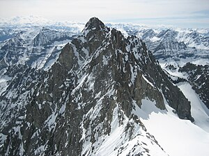
Pic de Bonvoisin
| Pic de Bonvoisin | ||
|---|---|---|
|
Pic de Bonvoisin, view from Pic Jocelme (northwest) 2012 |
||
| height | 3480 m | |
| location | Savoy department , France | |
| Mountains | Pelvoux | |
| Coordinates | 44 ° 49 '26 " N , 6 ° 20' 45" E | |
|
|
||
| First ascent | 1935 | |
The Pic de Bonvoisin is a 3480 m high mountain in the Écrins massif in the French department of Savoy ( Auvergne-Rhône-Alpes region ).
geography
The mountain is glaciated all around. On its northern slope is the Glacier de Bonvoisin , in the east the Glacier des Bruyères , in the south the Glacier de Surette and in the west the Glacier de Jocelme . On its eastern slope are the highest sources of the Onde , a right tributary of the Gyronde .
The summit marks the border between Vallouise-Pelvoux and La Chapelle-en-Valgaudémar .
history
The summit was first mentioned in the 1860s. The first ascent took place on July 20, 1935, a second ascent only after the Second World War on September 8, 1945. The mountain is neither economically nor touristic. The easiest way to get up is from the east by following the torrent des Bans from Vallouise . There is a parking lot for hikers and the Refuge des Bans refuge four kilometers to the west at 2083 m .
literature
- AW Moore The Alps in 1864, Volume 1

